GRACE DIEU and the possible site of the HOLIGOST
Listed on the National Heritage List for England. Search over 400,000 listed places
Overview
These rare 15th-century sites are the remains of two of Henry V’s four ‘great ships’: the Grace Dieu, one of the largest carracks (a type of wooden sailing ship) to be built but the victim of mutiny and a lightning strike; and the Holigost, a captured and repurposed Spanish vessel that was laid up after service in Henry’s navy. Read the official list entry.
- Heritage Category:
- Maritime Wreck
- List Entry Number:
- 1000061
- Date first listed:
- 12-Jan-1974
Location
Location of this list entry and nearby places that are also listed. Use our map search to find more listed places.
Use of this mapping is subject to terms and conditions.
This map is for quick reference purposes only and may not be to scale.
What is the National Heritage List for England?

The National Heritage List for England is a unique register of our country's most significant historic buildings and sites. The places on the list are protected by law and most are not open to the public.
The list includes:
🏠 Buildings
🏰 Scheduled monuments
🌳 Parks and gardens
⚔️ Battlefields
⚓ Shipwrecks
Historic England Archive
Search over 1 million photographs and drawings from the 1850s to the present day using our images archive.
Find PhotosOfficial list entry
- Heritage Category:
- Maritime Wreck
- List Entry Number:
- 1000061
- Date first listed:
- 12-Jan-1974
- Date of most recent amendment:
- 21-Jul-2016
- Location Description:
- River Hamble, nr. Lower Swanwick
The scope of legal protection for listed buildings
This list entry identifies a protected site which is understood to be the site of a vessel lying wrecked on or in the seabed. It's protected because of the historical, archaeological or artistic importance of the vessel, or of objects contained or formerly contained in it which may be lying on the seabed in or near the wreck.
Location
The building or site itself may lie within the boundary of more than one authority.
- Latitude:
- 50.89241878
- Longitude:
- -1.28869365
- National Grid Reference:
- SU5012510567
Summary
The Grace Dieu comprises the remains of an English carrack which was burnt in the River Hamble, Hampshire in 1439 after being struck by lightning. Built in 1418 for Henry V as a large clinker-built ship, part of the crew mutinied on its one known voyage, and the vessel never went to sea again, being laid up in Southampton Water for several years. The Grace Dieu was then towed upstream to its final mud berth on the River Hamble. Following the lightning strike of 1439 it was then partially broken up for salvage in the same location.
The restricted area also includes the remains of at least one other vessel; of particular interest are the possible remains of the Holigost, re-built in 1413-14 from a captured Spanish carrack, the Santa Clara. A contemporary of the Grace Dieu, the Holigost is documented as having decayed at Bursledon over the years 1437-47, having seen naval service with the English fleet.
Reasons for Designation
The wreck site known as the Grace Dieu is designated as a Protected Wreck Site for the following principal reasons:
Period: the site represents a well-documented naval vessel from the reign of Henry V, one of the largest clinker-built vessels ever constructed, and evidence of the transition to vessels of the carrack type in northern Europe at this time;
Rarity: sites of medieval shipwrecks are rare, and those capable of identification in the documentary record remain unusual among medieval vessels so far discovered;
Documentation: the vessel's build, use, and loss are all extensively documented from primary sources, as are the results of archaeological excavations demonstrating subsequent interventions on the site;
Potential: the vessel has the potential to inform on the development of northern European shipbuilding at a time of transition in the early 15th century, and consequently of the development and evolution of medieval warships.
The wreck site thought to represent the remains of the Holigost is included within the extended radius of the Protected Wreck Site of the Grace Dieu for the following principal reasons:
Period: the site represents the remains of a vessel thought to be the Holigost, a medieval vessel contemporary with the Grace Dieu;
Rarity: the sites of medieval shipwrecks are rare, and a second medieval wreck site in close proximity to another is unique;
Group value: the site has potential to be contemporary with the Grace Dieu, forming a unique assemblage of medieval vessels lost in a similar context;
Potential: this site has the potential to inform on the evolution of the medieval warship, including the nearby wreck of the Grace Dieu, and together with the Grace Dieu, on the development of the medieval mud docks at Bursledon.
History
At 1400 tons the Grace Dieu was the largest of Henry V's 'great ships', and one of the largest clinker-built vessels ever constructed. Work began on the ship in 1416, and in 1418 it was launched in Southampton. The one documented voyage of the Grace Dieu resulted in mutiny; in 1420 the vessel formed part of a force gathered at Southampton under the command of the Earl of Devonshire for sea-keeping patrol, and during that voyage a number of crewmen mutinied, forcing the master to put in at St. Helen's on the Isle of Wight. The Grace Dieu was then moored at Hamble but not neglected; it had a permanent crew of eight mariners until it was towed up the River Hamble to Bursledon and laid up in a dock. On the 7th of January 1439 it was struck by lightning and caught fire. Almost immediately after this date the process of salvage began; a gang of ten labourers set about recovering materials (especially metal fittings and fixtures) from the vessel, including the burned half of the mast that was sold with a ‘certain amount of old wood’ (1447-52 account of Richard Clivedon, Keeper of the King's Ships).
In a directory from 1859 the first reference is made to 'some timbers . . . still to be seen at very low water'. This is believed to refer to the site now known as the remains of the Grace Dieu. In 1875, a Mr F Crawshay removed some timbers from the inside of the wreck as part of his investigations, before his operations were stopped by the Board of Trade. His findings included details of a wreck 130ft long, 40ft wide and 12ft deep, with planking in three thicknesses, joints caulked with moss and fern leaves, visible saw marks on many timbers, timbers fastened together with 1.5 inch thick treenails and edges of boards fastened with iron nails. No other wreck in or near the site was noted at that time. Further excavations are recorded in 1899. The site was re-investigated in 1933 and tentatively identified as the site of the Grace Dieu at that time, an identification confirmed by the work of the National Maritime Museum in 1980-85. In 2004, a visit by Time Team television archaeologists with a team from Southampton University excavated part of the Grace Dieu.
Visible on an aerial photograph, an outline of a smaller vessel survives to the south-west of the Grace Dieu. Strong documentary evidence survives to indicate that this outline is the wreck of the Holigost, a contemporary of the Grace Dieu that was partially broken up at Bursledon over the period 1437-47. The history of Henry V's other 'great ships' is well-documented, particularly in the case of the Holigost, which was rebuilt as a 'great ship' out of a captured Spanish carrack, the Santa Clara in 1413-14. The Holigost joined the English fleet in November 1415 and took part in some of Henry V's subsequent naval campaigns at Harfleur and Bay of the Seine, after which, like the other 'great ships', it was laid up in or near Southampton. Its decay at Bursledon is well-documented over the years 1437-47, and accounts of the vessel being 'sunk in the sea and this way broken' survive from the period 1447-52.
Details
Designation History:
Designation Order: No 685, 2016
Made: 27 June 2016
Laid before Parliament: 30th June 2016
Coming into force: 21st July 2016
Protected area: 85 metres within 50 53.545N 01 17.322W
No part of the restricted area lies above the high-water mark of ordinary spring tides.
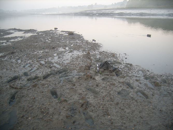
Grace Dieu: only the bottom part of the hull, a metre or so above the keel, now survives. The majority of the timbers, lying in the inter-tidal zone, are protected by silts; only 0.10 to 0.15m of framing projects above the present river bed. Structural features of the wreck include a keel of nearly 40m length, a keelson, 0.55m sided and 0.16m moulded with a simple mast-step, futtock timbers scarfed to the floor timbers, ceiling planking, stringers and crossbeams with protruding heads. In past years the natural protection has increased as soft mobile silts have extended towards the mainstream channel. The exposed timbers are in a firm and stable condition. Timbers closest to the east edge of the river are exposed for up to one hour on very low spring tides. Those at the other end of the vessel, the presumed stern, are permanently below low water mark, while those timbers lying in-between are uncovered for between one minute and one hour. Underwater conditions on the site are not conducive to efficient survey and recording by divers.
Holigost: a 'ship-shape' outline was first recorded to the south-west of the Grace Dieu in an aerial photograph of the Royal Commission on the Historical Monuments of England in 1979, with part of the site seen to be below the low water mark. It was subsequently proposed, on the grounds of its location in the same context and of its documentary history, as the possible remains of the Grace Dieu's contemporary, the Holigost. Rectification of the 1979 aerial photograph in 2015 suggests an extent of 10m by 6m. Probing below the mud in 1982 suggested that there were solid remains 6ft below the surface, and chirp survey in 2001 suggested an extent of at least 7m by 5m with potential for at least the lower part of the hull to survive in the mud. The site has not subsequently been exposed.
Legacy
The contents of this record have been generated from a legacy data system.
- Legacy System number:
- 1082121
- Legacy System:
- AMIE - Wrecks
Sources
Books and journals
Universal British Directory of Trade, Commerce and Manufacturing, (1793)
Bullar, A, Companion in a tour round Southampton, (1819)
Cant, S, England's Shipwreck Heritage: From Logboats to U-Boats, (2013)
Knight, P, Henry V and the Conquest of France, 1416-53, (1998), 39-41
White, W, History, Gazetteer and Directory of Hampshire and the Isle of Wight, (1859)
Friel, I, 'Henry V's Grace Dieu and the Wreck in the River Hamble near Bursledon, Hampshire' in International Journal of Nautical Archaeology, , Vol. 22.1, (1993), 3-19
Clarke, R, Dean, M, Hutchinson, G, McGrail, S, Squirrell, J, 'Recent work on the River Hamble wreck near Bursledon, Hampshire' in International Journal of Nautical Archaeology, , Vol. 22.1, (1993), 21-44
Fox, C F, 'Viking ship in the River Hamble' in Proceedings of the Hampshire Field Club, , Vol. 16, (1947), 163-165
Lowther, A W G, 'Date of timbers from the spire of Chilcomb Church and from the wreck in the River Hamble: some evidence from dendrochronology' in Proceedings of the Hampshire Field Club, , Vol. 17, (1951), 130-133
Anderson, R C, 'The Wreck in the Hamble River' in The Antiquaries Journal: Journal of the Society of Antiquaries of London, , Vol. XIV, (1934), 1-6
Brock, A R , 'Discovery of an ancient warship near Botley' in Journal of the British Archaeological Association, , Vol. 32, (1876), 70-71
Other
Friel, I, 2015A, Documentary evidence for the location of the Holy Ghost at Bursledon
Friel, I, 2015B, Henry V's great ship Holy Ghost and the 'ship-shape' site at Bursledon
Newspaper: The Graphic, 27 November 1875, p518
Steyne, H, 2003, An Integrated investigation into Henry V's Warships the Holigost and Trinity Royal, and the Bursledon II wreck site in the River Hamble, Hampshire. Unpublished MA Dissertation
Legal
This site is designated under the Protection of Wrecks Act 1973 as it is or may prove to be the site of a vessel lying wrecked on or in the sea bed and, on account of the historical, archaeological or artistic importance of the vessel, or of any objects contained or formerly contained in it which may be lying on the sea bed in or near the wreck, it ought to be protected from unauthorised interference. Protected wreck sites are designated by Statutory Instrument. The following information has been extracted from the relevant Statutory Instrument.
Statutory Instrument
Information provided under the Statutory Instrument heading below forms part of the official record of a protected wreck site. Information provided under other headings does not form part of the official record of the designation. It has been compiled by Historic England to aid understanding of the protected wreck site.
Statutory Instruments: 1974/56, 2016/685

Chart
This map is for quick reference purposes only and may not be to scale. This copy shows the entry on 05-May-2025 at 11:08:13.
Download a full scale chart (PDF)© Crown copyright [and database rights] 2025. OS AC0000815036. All rights reserved. Ordnance Survey Licence number 100024900.© British Crown and SeaZone Solutions Limited 2025. All rights reserved. Licence number 102006.006.
End of official list entry


