THE GATEHOUSE
THE GATEHOUSE
Listed on the National Heritage List for England. Search over 400,000 listed places
Overview
- Heritage Category:
- Listed Building
- Grade:
- I
- List Entry Number:
- 1258142
- Date first listed:
- 15-Jan-1968
- List Entry Name:
- THE GATEHOUSE
- Statutory Address:
- THE GATEHOUSE
Location
Location of this list entry and nearby places that are also listed. Use our map search to find more listed places.
Use of this mapping is subject to terms and conditions.
This map is for quick reference purposes only and may not be to scale.
What is the National Heritage List for England?

The National Heritage List for England is a unique register of our country's most significant historic buildings and sites. The places on the list are protected by law and most are not open to the public.
The list includes:
🏠 Buildings
🏰 Scheduled monuments
🌳 Parks and gardens
⚔️ Battlefields
⚓ Shipwrecks
Images of England Project
- Date:
- 1999-08-15
- Reference:
- IOE01/01820/25
- Rights:
- © Mr Howard Bagshaw. Source: Historic England Archive
Historic England Archive
Search over 1 million photographs and drawings from the 1850s to the present day using our images archive.
Find PhotosOfficial list entry
- Heritage Category:
- Listed Building
- Grade:
- I
- List Entry Number:
- 1258142
- Date first listed:
- 15-Jan-1968
- List Entry Name:
- THE GATEHOUSE
- Statutory Address 1:
- THE GATEHOUSE
The scope of legal protection for listed buildings
This List entry helps identify the building designated at this address for its special architectural or historic interest.
Unless the List entry states otherwise, it includes both the structure itself and any object or structure fixed to it (whether inside or outside) as well as any object or structure within the curtilage of the building.
For these purposes, to be included within the curtilage of the building, the object or structure must have formed part of the land since before 1st July 1948.
Location
- Statutory Address:
- THE GATEHOUSE
The building or site itself may lie within the boundary of more than one authority.
- County:
- Staffordshire
- District:
- Stafford (District Authority)
- Parish:
- Tixall
- National Grid Reference:
- SJ 97911 22948
Details
TIKALL
1.
2385
SJ 92 SE 19/2B The Gatehouse
15.1.68.
I
2.
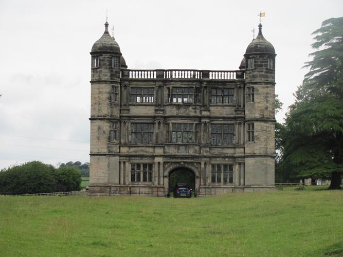
Built circa 1575 and a very stylish specimen of Elizabethan design. Ashlar
faced and retangular with octagonal ogee-domed turrets at the angles and
central. archway. 3 storeys, each decorated with an Order of columns: Doric,
Ionic and Corinthian, Balustraded parapet. The interior is gutted and
the roof almost gone. Mullioned and transomed windows.
Listing NGR: SJ9791122948
Legacy
The contents of this record have been generated from a legacy data system.
- Legacy System number:
- 444427
- Legacy System:
- LBS
Legal
This building is listed under the Planning (Listed Buildings and Conservation Areas) Act 1990 as amended for its special architectural or historic interest.

Map
This map is for quick reference purposes only and may not be to scale. This copy shows the entry on 16-Apr-2025 at 17:08:59.
Download a full scale map (PDF)© Crown copyright [and database rights] 2025. OS AC0000815036. All rights reserved. Ordnance Survey Licence number 100024900.© British Crown and SeaZone Solutions Limited 2025. All rights reserved. Licence number 102006.006.
End of official list entry


