CHURCH OF ALL SAINTS
CHURCH OF ALL SAINTS, SOCKBURN LANE
Listed on the National Heritage List for England. Search over 400,000 listed places
Overview
- Heritage Category:
- Listed Building
- Grade:
- I
- List Entry Number:
- 1185947
- Date first listed:
- 20-Mar-1967
- List Entry Name:
- CHURCH OF ALL SAINTS
- Statutory Address:
- CHURCH OF ALL SAINTS, SOCKBURN LANE
Location
Location of this list entry and nearby places that are also listed. Use our map search to find more listed places.
Use of this mapping is subject to terms and conditions.
This map is for quick reference purposes only and may not be to scale.
What is the National Heritage List for England?

The National Heritage List for England is a unique register of our country's most significant historic buildings and sites. The places on the list are protected by law and most are not open to the public.
The list includes:
🏠 Buildings
🏰 Scheduled monuments
🌳 Parks and gardens
⚔️ Battlefields
⚓ Shipwrecks
Images of England Project
- Date:
- 2007-03-23
- Reference:
- IOE01/14657/18
- Rights:
- © Mr Alan Bradley. Source: Historic England Archive
Historic England Archive
Search over 1 million photographs and drawings from the 1850s to the present day using our images archive.
Find PhotosOfficial list entry
- Heritage Category:
- Listed Building
- Grade:
- I
- List Entry Number:
- 1185947
- Date first listed:
- 20-Mar-1967
- List Entry Name:
- CHURCH OF ALL SAINTS
- Statutory Address 1:
- CHURCH OF ALL SAINTS, SOCKBURN LANE
The scope of legal protection for listed buildings
This List entry helps identify the building designated at this address for its special architectural or historic interest.
Unless the List entry states otherwise, it includes both the structure itself and any object or structure fixed to it (whether inside or outside) as well as any object or structure within the curtilage of the building.
For these purposes, to be included within the curtilage of the building, the object or structure must have formed part of the land since before 1st July 1948.
Location
- Statutory Address:
- CHURCH OF ALL SAINTS, SOCKBURN LANE
The building or site itself may lie within the boundary of more than one authority.
- District:
- Darlington (Unitary Authority)
- Parish:
- Neasham
- National Grid Reference:
- NZ3498207113
Details
SOCKBURN SOCKBURN LANE
NZ 3407 (South end, off)
19/39 Church of All Saints
20/3/67
I
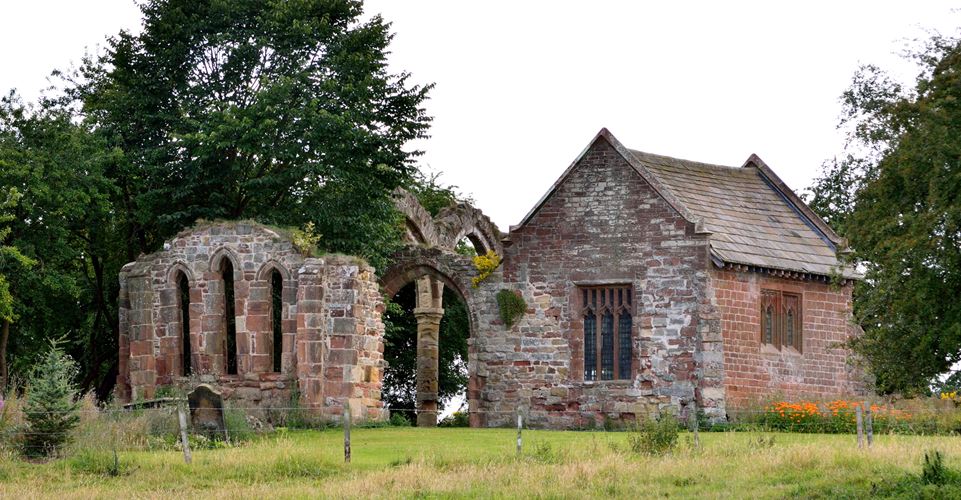
Ruined church. Pre-Conquest nave and chancel; late C12 south aisle; chancel
rebuilt early C13; C14 chantry, now Conyers, chapel was restored and re-roofed
1900 by W.H. Knowles. Squared red sandstone; Conyers chapel has stone-flagged
roof. Roofless nave with fragmentary foundations of aisle on south and
Conyers chapel on north; roofless chancel. Early English nave arcade and
chancel; restored windows with Perpendicular-style tracery in Conyers chapel.
Tall, narrow 2-bay nave. Quoins of long-and-short work were noted in 1900
by W.H. Knowles but were concealed by vegetation at time of survey. South
aisle has disappeared but 2-bay arcade remains: 2 double-chamfered pointed
arches on central pier with square plinth, chamfered base and moulded octagonal
capital. Foundations only of north and south chancel walls. Double-chamfered
pointed chancel arch on mid-wall corbels. Flat-buttressed east end stands
almost to full height and has chamfered plinth and 3 stepped lancets with
chamfered reveals, linked hoodmoulds and deeply-splayed rear-arches. 2-bay
Conyers chapel: chamfered plinth on north and west; largely-rebuilt, diagonally-
buttressed north wall; wide double-chamfered pointed arch in south wall;
2- and 3-light square-headed windows with Perpendicular tracery; steeply-
pitched roof with moulded coped gables and shaped footstones.
The Conyers chapel contains a superb collection of well-preserved sculpture
including: pre-Conquest cross shafts, hog-backed and tegulated grave covers,
cross heads; medieval grave covers, some with C14 and C15 inlaid brasses to
members of the Conyers family, fragment of square-headed window tracery,
circular font bowl and 2 carved panels possibly from an altar tomb; mid C13
effigy of a cross-legged knight.
Scheduled Ancient Monument.
(W.H. Knowles, "Sockburn Church", Transactions of the Architectural and
Archaeological Society of Northumberland and Durham, Vol. 5, 1905).
(J.T. Lang, "Illustrative carvings of the Viking period at Sockburn on Tees",
Archaeologia Aeliana, 4th Series, Vol. 50, 1972).
Listing NGR: NZ3497607106
Legacy
The contents of this record have been generated from a legacy data system.
- Legacy System number:
- 350498
- Legacy System:
- LBS
Sources
Books and journals
'Transactions Architectural and Archaeological Society of Northumberland and Durh' in Transactions Architectural and Archaeological Society of Northumberland and Durh, , Vol. 5, (1905)
'Archaeologia Aeliana' in Archaeologia Aeliana, , Vol. 50, (1972)
Legal
This building is listed under the Planning (Listed Buildings and Conservation Areas) Act 1990 as amended for its special architectural or historic interest.

Map
This map is for quick reference purposes only and may not be to scale. This copy shows the entry on 16-Apr-2025 at 17:19:33.
Download a full scale map (PDF)© Crown copyright [and database rights] 2025. OS AC0000815036. All rights reserved. Ordnance Survey Licence number 100024900.© British Crown and SeaZone Solutions Limited 2025. All rights reserved. Licence number 102006.006.
End of official list entry


