CREEKSEA PLACE
CREEKSEA PLACE, FERRY ROAD
Listed on the National Heritage List for England. Search over 400,000 listed places
Overview
- Heritage Category:
- Listed Building
- Grade:
- II*
- List Entry Number:
- 1123776
- Date first listed:
- 10-Nov-1951
- List Entry Name:
- CREEKSEA PLACE
- Statutory Address:
- CREEKSEA PLACE, FERRY ROAD
Location
Location of this list entry and nearby places that are also listed. Use our map search to find more listed places.
Use of this mapping is subject to terms and conditions.
This map is for quick reference purposes only and may not be to scale.
What is the National Heritage List for England?

The National Heritage List for England is a unique register of our country's most significant historic buildings and sites. The places on the list are protected by law and most are not open to the public.
The list includes:
🏠 Buildings
🏰 Scheduled monuments
🌳 Parks and gardens
⚔️ Battlefields
⚓ Shipwrecks
Images of England Project
- Date:
- 2002-04-16
- Reference:
- IOE01/06684/06
- Rights:
- © Mrs Angela Clark. Source: Historic England Archive
Historic England Archive
Search over 1 million photographs and drawings from the 1850s to the present day using our images archive.
Find PhotosOfficial list entry
- Heritage Category:
- Listed Building
- Grade:
- II*
- List Entry Number:
- 1123776
- Date first listed:
- 10-Nov-1951
- Date of most recent amendment:
- 27-Jan-1975
- List Entry Name:
- CREEKSEA PLACE
- Statutory Address 1:
- CREEKSEA PLACE, FERRY ROAD
The scope of legal protection for listed buildings
This List entry helps identify the building designated at this address for its special architectural or historic interest.
Unless the List entry states otherwise, it includes both the structure itself and any object or structure fixed to it (whether inside or outside) as well as any object or structure within the curtilage of the building.
For these purposes, to be included within the curtilage of the building, the object or structure must have formed part of the land since before 1st July 1948.
Location
- Statutory Address:
- CREEKSEA PLACE, FERRY ROAD
The building or site itself may lie within the boundary of more than one authority.
- County:
- Essex
- District:
- Maldon (District Authority)
- Parish:
- Burnham-on-Crouch
- National Grid Reference:
- TQ 93449 96163
Details
FERRY ROAD
1. CREEKSEA
5217
Creeksea Place
(Formerly listed under
Creeksea)
TQ 99 NW 2/26 10.11.51
II*
2.
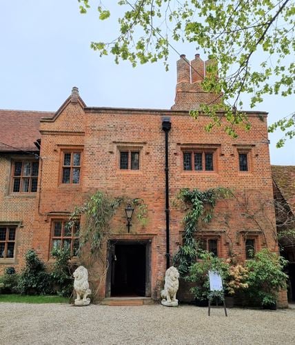
Part of a large C16 red brick house standing in a park of about 30 acres.
The original building was completed in 1569 (The date on an original rain
water head in the north wing). It comprised 3 or 4 ranges with a courtyard.
The south range was destroyed in 1740 and only the east and north wings
now remain. The east wing was built in the C19 on the foundations of
the old structure. There are a number of original features in the north
range, windows, chimneystacks and an original staircase on the south side.
The main block is 2 storeys and a subsidiary range of 1 storey and attics
extends to the west. The windows are brick mullioned and transomed and
mullioned, with lattice leaded lights. The roof of the lower block is
tiled, with 4 gabled dormers. The interior has a number of original features.
Listing NGR: TQ9344996163
Legacy
The contents of this record have been generated from a legacy data system.
- Legacy System number:
- 116583
- Legacy System:
- LBS
Legal
This building is listed under the Planning (Listed Buildings and Conservation Areas) Act 1990 as amended for its special architectural or historic interest.

Map
This map is for quick reference purposes only and may not be to scale. This copy shows the entry on 17-Jun-2025 at 09:01:38.
Download a full scale map (PDF)© Crown copyright [and database rights] 2025. OS AC0000815036. All rights reserved. Ordnance Survey Licence number 100024900.© British Crown and SeaZone Solutions Limited 2025. All rights reserved. Licence number 102006.006.
End of official list entry


