JACOB'S LADDER
JACOB'S LADDER, MILITARY ROAD
Listed on the National Heritage List for England. Search over 400,000 listed places
Overview
- Heritage Category:
- Listed Building
- Grade:
- II
- List Entry Number:
- 1031336
- Date first listed:
- 30-Oct-1985
- List Entry Name:
- JACOB'S LADDER
- Statutory Address:
- JACOB'S LADDER, MILITARY ROAD
Location
Location of this list entry and nearby places that are also listed. Use our map search to find more listed places.
Use of this mapping is subject to terms and conditions.
This map is for quick reference purposes only and may not be to scale.
What is the National Heritage List for England?

The National Heritage List for England is a unique register of our country's most significant historic buildings and sites. The places on the list are protected by law and most are not open to the public.
The list includes:
🏠 Buildings
🏰 Scheduled monuments
🌳 Parks and gardens
⚔️ Battlefields
⚓ Shipwrecks
Images of England Project
- Date:
- 2003-02-25
- Reference:
- IOE01/10148/10
- Rights:
- © Mr Peter Hubbard. Source: Historic England Archive
Historic England Archive
Search over 1 million photographs and drawings from the 1850s to the present day using our images archive.
Find PhotosAlso of interest

Official list entry
- Heritage Category:
- Listed Building
- Grade:
- II
- List Entry Number:
- 1031336
- Date first listed:
- 30-Oct-1985
- List Entry Name:
- JACOB'S LADDER
- Statutory Address 1:
- JACOB'S LADDER, MILITARY ROAD
The scope of legal protection for listed buildings
This List entry helps identify the building designated at this address for its special architectural or historic interest.
Unless the List entry states otherwise, it includes both the structure itself and any object or structure fixed to it (whether inside or outside) as well as any object or structure within the curtilage of the building.
For these purposes, to be included within the curtilage of the building, the object or structure must have formed part of the land since before 1st July 1948.
Location
- Statutory Address:
- JACOB'S LADDER, MILITARY ROAD
The building or site itself may lie within the boundary of more than one authority.
- County:
- Kent
- District:
- Thanet (District Authority)
- Parish:
- Ramsgate
- National Grid Reference:
- TR 38106 64506
Details
RAMSGATE ROYAL HARBOUR
TR 3864 NW
(Military Road)
13/355 Jacob's Ladder
30.10.85
GV II
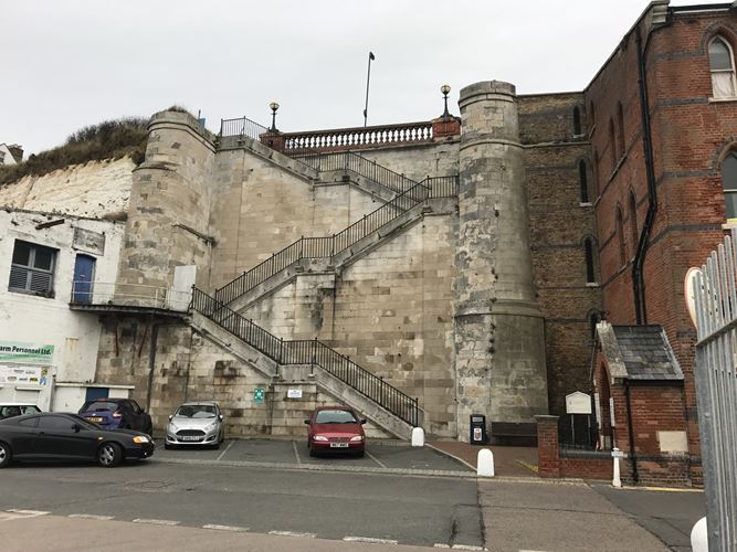
Flight of steps. 1826 by John Shaw. Ashlar. Dog-leg stairs with three
flights of steps faced with ashlar and built between flanking towers with
rounded fronts of ashlar, each flight of steps with wide central pilaster;
centre landings. Iron balustrade. Flights of steps and towers with ashlar
coping. The present stair replaces an earlier wooden flight of c.1750,
100 yards east. (Busson, Ramsgate, Cap.3; Matkin, Maritime Thanet).
Listing NGR: TR3810664506
Legacy
The contents of this record have been generated from a legacy data system.
- Legacy System number:
- 171991
- Legacy System:
- LBS
Sources
Books and journals
Busson, C , Book of Ramsgate
Matkin, R B, Maritime Thanet, (1982)
Legal
This building is listed under the Planning (Listed Buildings and Conservation Areas) Act 1990 as amended for its special architectural or historic interest.

Map
This map is for quick reference purposes only and may not be to scale. This copy shows the entry on 13-Jun-2025 at 10:07:40.
Download a full scale map (PDF)© Crown copyright [and database rights] 2025. OS AC0000815036. All rights reserved. Ordnance Survey Licence number 100024900.© British Crown and SeaZone Solutions Limited 2025. All rights reserved. Licence number 102006.006.
End of official list entry


