32, CLOSE
32, CLOSE
Listed on the National Heritage List for England. Search over 400,000 listed places
Overview
- Heritage Category:
- Listed Building
- Grade:
- II*
- List Entry Number:
- 1024916
- Date first listed:
- 14-Jun-1954
- List Entry Name:
- 32, CLOSE
- Statutory Address:
- 32, CLOSE
Location
Location of this list entry and nearby places that are also listed. Use our map search to find more listed places.
Use of this mapping is subject to terms and conditions.
This map is for quick reference purposes only and may not be to scale.
What is the National Heritage List for England?

The National Heritage List for England is a unique register of our country's most significant historic buildings and sites. The places on the list are protected by law and most are not open to the public.
The list includes:
🏠 Buildings
🏰 Scheduled monuments
🌳 Parks and gardens
⚔️ Battlefields
⚓ Shipwrecks
Images of England Project
- Date:
- 2000-06-10
- Reference:
- IOE01/02260/15
- Rights:
- © D.S Ridley. Source: Historic England Archive
Historic England Archive
Search over 1 million photographs and drawings from the 1850s to the present day using our images archive.
Find PhotosOfficial list entry
- Heritage Category:
- Listed Building
- Grade:
- II*
- List Entry Number:
- 1024916
- Date first listed:
- 14-Jun-1954
- List Entry Name:
- 32, CLOSE
- Statutory Address 1:
- 32, CLOSE
The scope of legal protection for listed buildings
This List entry helps identify the building designated at this address for its special architectural or historic interest.
Unless the List entry states otherwise, it includes both the structure itself and any object or structure fixed to it (whether inside or outside) as well as any object or structure within the curtilage of the building.
For these purposes, to be included within the curtilage of the building, the object or structure must have formed part of the land since before 1st July 1948.
Location
- Statutory Address:
- 32, CLOSE
The building or site itself may lie within the boundary of more than one authority.
- District:
- Newcastle upon Tyne (Metropolitan Authority)
- Parish:
- Non Civil Parish
- National Grid Reference:
- NZ 25038 63762
Details
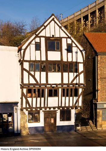
NZ 2563 NW NEWCASTLE UPON TYNE CLOSE
(north side)
24/189 No. 32
14/6/54
G.V. II*
House, later cooperage, now public house and restaurant. C15 and later. Sand-
stone ground floor and right return of first floor supporting timber-framed
upper floors with rendered infill; brick nogging on right return. Pantiled roof.
Gabled front of 3 storeys, one bay. Central plain wooden door under wood lintel
flanked by plain 2-light windows. Jettied first and second floors have plain
windows in upper part of each floor; diagonal corner bracing to these floors.
Top gable has curved principals and studs with plain window inserted in central
blocked hoist opening. Interior shows curved principals, some truncated at
collars at apex.
Listing NGR: NZ2503863762
Legacy
The contents of this record have been generated from a legacy data system.
- Legacy System number:
- 304496
- Legacy System:
- LBS
Legal
This building is listed under the Planning (Listed Buildings and Conservation Areas) Act 1990 as amended for its special architectural or historic interest.

Map
This map is for quick reference purposes only and may not be to scale. This copy shows the entry on 16-Apr-2025 at 16:36:08.
Download a full scale map (PDF)© Crown copyright [and database rights] 2025. OS AC0000815036. All rights reserved. Ordnance Survey Licence number 100024900.© British Crown and SeaZone Solutions Limited 2025. All rights reserved. Licence number 102006.006.
End of official list entry


