Late medieval packhorse bridge 35m north of St Thomas's Church, Newport
Listed on the National Heritage List for England. Search over 400,000 listed places
Overview
- Heritage Category:
- Scheduled Monument
- List Entry Number:
- 1020634
- Date first listed:
- 17-Apr-1957
Location
Location of this list entry and nearby places that are also listed. Use our map search to find more listed places.
Use of this mapping is subject to terms and conditions.
This map is for quick reference purposes only and may not be to scale.
What is the National Heritage List for England?

The National Heritage List for England is a unique register of our country's most significant historic buildings and sites. The places on the list are protected by law and most are not open to the public.
The list includes:
🏠 Buildings
🏰 Scheduled monuments
🌳 Parks and gardens
⚔️ Battlefields
⚓ Shipwrecks
Historic England Archive
Search over 1 million photographs and drawings from the 1850s to the present day using our images archive.
Find PhotosOfficial list entry
- Heritage Category:
- Scheduled Monument
- List Entry Number:
- 1020634
- Date first listed:
- 17-Apr-1957
- Date of most recent amendment:
- 24-Jul-2002
Location
The building or site itself may lie within the boundary of more than one authority.
- District:
- Cornwall (Unitary Authority)
- Parish:
- Launceston
- National Grid Reference:
- SX 32788 85096
Reasons for Designation
Multi-span bridges are structures of two or more arches supported on
piers. They were constructed throughout the medieval period for the use
of pedestrians and packhorse or vehicular traffic, crossing rivers or
streams, often replacing or supplementing earlier fords. During the early
medieval period timber was used, but from the 12th century stone (and
later brick) bridges became more common, with the piers sometimes
supported by a timber raft. Most stone or brick bridges were constructed
with pointed arches, although semicircular and segmental examples are also
known. A common medieval feature is the presence of stone ashlar ribs
underneath the arch. The bridge abutments and revetting of the river banks
also form part of the bridge. Where medieval bridges have been altered in
later centuries, original features are sometimes concealed behind later
stonework, including remains of earlier timber bridges. The roadway was
often originally cobbled or gravelled. The building and maintenance of
bridges was frequently carried out by the church and by guilds, although
landowners were also required to maintain bridges. From the mid-13th
century the right to collect tolls, known as pontage, was granted to many
bridges, usually for repairs; for this purpose many urban bridges had
houses or chapels on them, and some were fortified with a defensive
gateway. Medieval multi-span bridges must have been numerous throughout
England, but most have been rebuilt or replaced and less than 200 examples
are now known to survive. As a rare monument type largely unaltered,
surviving examples and examples that retain significant medieval and post-
medieval fabric are considered to be of national importance.
The late medieval packhorse bridge 35m north of St Thomas's Church at
Newport survives well despite limited modifications. It retains much of
its original form and structure, including an absence of parapets typical
of medieval packhorse bridges, and provides a good example of late
medieval bridge-building in south west England. Its historical context,
linking the adjacent Launceston Priory with the neighbouring settlement of
Newport, gives a good illustration of the role of medieval religious
houses in bridge building. The survival nearby of the ford preceding this
bridge and of the 18th century bridge which replaced it illustrate clearly
the considerable development both of river crossings and of the highway
system during and since the medieval period. The effect of that
development on the use of the bridge is shown by the addition of the
railings to the bridge, effectively preventing its use by vehicular
traffic while providing a safety measure for its continued pedestrian use.
Details
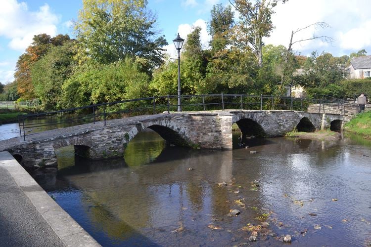
The monument includes a packhorse bridge, sometimes known as St Thomas's
Bridge or the West Bridge, crossing the River Kensey at Newport, north of
Launceston in east Cornwall. The bridge is largely of late medieval date with
some later modification. The bridge is Listed Grade I.
The bridge spans the River Kensey north-south by five small arches, increasing
in height and span to the central arch. The arches vary in form: the central
arch is almost rounded; those to each side of it are slightly pointed arches,
while the outermost arches are segmental. A circular concrete pipe passing
beneath the southern end of the bridge is a modern addition. The central arch
is flanked by pointed cutwaters on its upstream, western, side. Between the
two southern arches, the cutwater function is performed by a large boulder
resting on masonry projecting from the base of the pier, considered to be the
impromptu repair of a severely damaged former cutwater. On its downstream
side, a single cutwater is located south of the central arch. The fabric of
the arches, piers and cutwaters is generally of local metamorphic stone but
granite blocks are used to face the apex of the upstream cutwater south of the
central arch.
The bridge's carriageway, 25.2m long overall, rises gently to its highest
point over the central arch. Generally 2.4m-2.6m wide but up to 5.5m
across the cutwaters south of the central arch, the carriageway lacks a
parapet but along each side it is edged by slate slabs to 0.5m wide, many
secured by iron cramps and laid flush with the surface, some slightly
overhanging the faces of the bridge below. Between the slate edging, the
carriageway is cobbled by small pebbles in a concrete bed. Along each side
of the carriageway is a railing of wrought iron uprights linked by two
rails, considered to be 18th or 19th century in date. The railings'
uprights are secured into granite slabs which cross the carriageway
transversely at approximately 2m intervals. A late 19th century cast iron
lamp post stands on the southern of the upstream cutwaters, its original
gas lamp since converted to electricity.
Construction of the bridge has been attributed to the 15th century work of
Launceston Priory, sited on the adjacent land south of the river beside
the still extant church of St Thomas. Following the refoundation of the
Priory there in 1155 from its former site at St Stephen's to the north,
the settlement of Newport developed on the north bank of the river. Until
the bridge was built, the Priory and its dependent settlement were linked
by a ford still visible across the River Kensey beyond this scheduling,
several metres upstream from the bridge. The severe limitations posed by
this bridge to increasing post-medieval traffic resulted, in the 18th
century, in a larger bridge being built 85m downstream and beyond this
scheduling. Consequently, this bridge is now legally and physically
restricted to pedestrian use.
All modern drains, electricity cables and trenches, the 19th century
lamppost and its lamp, the modern road metalling south of the bridge, the
modern walls, and the brick and concrete surfaces north of the bridge are
excluded from the scheduling, although the ground beneath them is
included.
MAP EXTRACT
The site of the monument is shown on the attached map extract.
Legacy
The contents of this record have been generated from a legacy data system.
- Legacy System number:
- 15571
- Legacy System:
- RSM
Sources
Books and journals
Henderson, C, Coates, H, Old Cornish Bridges and Streams, (1928)
Hull, P L , 'D and C Record Soc Volumes New Series' in The Cartulary of Launceston Priory (Lambeth Palace MS 719), , Vol. 30, (1987)
Other
Consulted 4/2001, CAU, Cornwall SMR entry for PRN 2612,
DoE, Listed Building entry for SX 3285 660 - 1/3/238,
Ministry of Works , AM7 scheduling docmtn & maplet for SAM CO 381 St Thomas's Bridge, 1956,
Ministry of Works , AM7 scheduling documentation and maplet for SAM CO 382 Packhorse Bridge, 1956,
Legal
This monument is scheduled under the Ancient Monuments and Archaeological Areas Act 1979 as amended as it appears to the Secretary of State to be of national importance. This entry is a copy, the original is held by the Department for Culture, Media and Sport.

Map
This map is for quick reference purposes only and may not be to scale. This copy shows the entry on 16-Apr-2025 at 16:38:23.
Download a full scale map (PDF)© Crown copyright [and database rights] 2025. OS AC0000815036. All rights reserved. Ordnance Survey Licence number 100024900.© British Crown and SeaZone Solutions Limited 2025. All rights reserved. Licence number 102006.006.
End of official list entry


