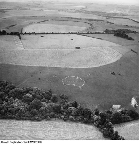
Chalk map of Australia 925m south west of Upper Hurdcott Farm
Listed on the National Heritage List for England. Search over 400,000 listed places
Overview
- Heritage Category:
- Scheduled Monument
- List Entry Number:
- 1020133
- Date first listed:
- 01-Jun-2001
Location
Location of this list entry and nearby places that are also listed. Use our map search to find more listed places.
Use of this mapping is subject to terms and conditions.
This map is for quick reference purposes only and may not be to scale.
What is the National Heritage List for England?

The National Heritage List for England is a unique register of our country's most significant historic buildings and sites. The places on the list are protected by law and most are not open to the public.
The list includes:
🏠 Buildings
🏰 Scheduled monuments
🌳 Parks and gardens
⚔️ Battlefields
⚓ Shipwrecks
Historic England Archive
Search over 1 million photographs and drawings from the 1850s to the present day using our images archive.
Find PhotosOfficial list entry
- Heritage Category:
- Scheduled Monument
- List Entry Number:
- 1020133
- Date first listed:
- 01-Jun-2001
Location
The building or site itself may lie within the boundary of more than one authority.
- District:
- Wiltshire (Unitary Authority)
- Parish:
- Compton Chamberlayne
- National Grid Reference:
- SU 04298 29163
Reasons for Designation
Constructed by either stripping the turf to expose the bedrock beneath, or by cutting bedding trenches and packing them with chalk rubble, hill figures are an extremely rare phenomenon nationally with only 40 or so identified, most of which are to be found on the chalk downs of southern England. Archaeological opinion is divided as to the date of the earliest examples, some of which may have their origins in the late prehistoric or Romano-British period. However, most appear to belong to the post-medieval period, of which those from the 20th century are by far the most numerous with 26 examples recorded nationally. With the exception of one figure cut as an advertisement, the remainder of 20th century hill figures appear to have been cut for commemorative purposes, with a significant proportion dating to World War I and intended to record the presence of military units in specific localities. The 19 badges and motifs either visible today as surface features or surviving as buried deposits on Fovant, Compton and Sutton Downs represent by far the largest and most complete group of hill figures in England. They are prominent features in the landscape and along with the military graves in nearby churchyards are a visible record of the importance of the area during World War I. Their significance is further enhanced by their association with a number of regiments or units which were either subsequently disbanded, or whose members left Fovant to fight in some of the most bloody battles of World War I.
Details
The monument includes a chalk map of Australia cut into the northern slope of
Compton Down, overlooking the village of Compton Chamberlayne.
The map, which was constructed by excavating a series of shallow bedding
trenches into which clean chalk rubble was inserted and compressed into place,
consists of a simple outline of the Australian continent, within which is the
legend `Australia'. It was originally cut by troops belonging to the
Australian Imperial Force, Australia's expeditionary force. The Australians
underwent training in the locality during August 1916 and March 1917 but took
over many of the camps around Fovant from October 1917 until after the
Armistice, when the camps were used as dispersal centres for those awaiting
repatriation.
A further series of contemporary chalk badges on Fovant and Sutton Downs are
the subject of separate schedulings.
All fences are excluded from the scheduling, although the ground beneath them
is included.
MAP EXTRACT
The site of the monument is shown on the attached map extract.
It includes a 2 metre boundary around the archaeological features,
considered to be essential for the monument's support and preservation.
Legacy
The contents of this record have been generated from a legacy data system.
- Legacy System number:
- 33963
- Legacy System:
- RSM
Sources
Books and journals
The Fovant Badges Society, (1916)
Legal
This monument is scheduled under the Ancient Monuments and Archaeological Areas Act 1979 as amended as it appears to the Secretary of State to be of national importance. This entry is a copy, the original is held by the Department for Culture, Media and Sport.

Map
This map is for quick reference purposes only and may not be to scale. This copy shows the entry on 21-Apr-2025 at 11:10:01.
Download a full scale map (PDF)© Crown copyright [and database rights] 2025. OS AC0000815036. All rights reserved. Ordnance Survey Licence number 100024900.© British Crown and SeaZone Solutions Limited 2025. All rights reserved. Licence number 102006.006.
End of official list entry


