Cold War Heavy Anti-aircraft gun site, 330m and 220m north east of Halls Green Farm
Listed on the National Heritage List for England. Search over 400,000 listed places
Overview
- Heritage Category:
- Scheduled Monument
- List Entry Number:
- 1019890
- Date first listed:
- 25-Jun-2001
Location
Location of this list entry and nearby places that are also listed. Use our map search to find more listed places.
Use of this mapping is subject to terms and conditions.
This map is for quick reference purposes only and may not be to scale.
What is the National Heritage List for England?

The National Heritage List for England is a unique register of our country's most significant historic buildings and sites. The places on the list are protected by law and most are not open to the public.
The list includes:
🏠 Buildings
🏰 Scheduled monuments
🌳 Parks and gardens
⚔️ Battlefields
⚓ Shipwrecks
Historic England Archive
Search over 1 million photographs and drawings from the 1850s to the present day using our images archive.
Find PhotosOfficial list entry
- Heritage Category:
- Scheduled Monument
- List Entry Number:
- 1019890
- Date first listed:
- 25-Jun-2001
Location
The building or site itself may lie within the boundary of more than one authority.
- County:
- Essex
- District:
- Epping Forest (District Authority)
- Parish:
- Roydon
- National Grid Reference:
- TL 41748 08730, TL 41757 08579
Reasons for Designation
The archaeological remains of the Cold War are the physical manifestation of
the global division between capitalism and communism that shaped the history
of the late 20th century. Of the many monument classes that characterise this
period Heavy Anti-aircraft (HAA) Batteries formed an integral part of the
United Kingdom's anti-aircraft defences, and are an example of how the early
Cold War defence strategy looked back to World War II for its inspiration. It
was a system designed to counter the perceived contemporary Soviet nuclear
threat, comprising manned turboprop bombers carrying atomic bombs to attack
major conurbations. By the mid-1950s advancing technology, in the form of fast
jet bombers, the development of the hydrogen bomb, and the threat of long-
range rockets had rendered the system obsolete.
Post-war HAA Batteries, grouped around the major conurbations and armament
producing areas, formed part of an elaborate anti-aircraft defence system.
This also included radar stations, the Royal Observer Corps, interceptor
aircraft, Anti-aircraft Operations Rooms and Light Anti-aircraft batteries.
There are two principal types of post-World War II batteries: those for the
smaller calibre 3.7-inch guns, and those for the heavy 5.25-inch guns. The
smaller calibre sites usually include four emplacements arranged in a shallow
arc with the guns mounted in each on central holdfasts. The 5.25-inch
emplacements are far more elaborate, with a deep pit beneath each gun, housing
the powerful hydraulic systems needed to absorb the recoil from the shells and
the automated loading systems. Associated with both types of battery are gun
stores, standby generator buildings, command posts, structures or hard
standings for gun-laying radar and predictors, domestic accommodation and
other minor features. Some are associated with contemporary Anti-aircraft
Operations Rooms.
Following a comprehensive survey and assessment of Cold War monuments in
England, the location and type of each post-war HAA battery is known. During
World War II nearly 1,000 anti-aircraft gun sites were built, of which 192
were selected for retention as the `Nucleus Force'. By 1950 the scheme had
been reorganised to cover three key areas; Forth/Clyde, Mersey/Midlands and
London/South East - this scheme was known as `Igloo' and comprised 78 sites,
54 of which had guns permanently mounted. However, a year later, in response
to fears about the Soviet Union's aggressive intentions, heightened by the
outbreak of the Korean War, 683 HAA batteries were listed in a mobilisation
plan. These represented a mixture of retained or reoccupied wartime sites,
often with new additions, and sites built in greenfield locations.
Any HAA battery, constructed after 1945, which has significant surviving
remains, including its gun pits, is considered to be of national importance.
The Cold War Heavy Anti-aircraft gun site 330m and 220m north east of Halls
Green Farm survives well, retaining the principal features which illustrate
both its purpose and its method of operation. Based on present evidence, LN70
is thought to be one of only about eight such sites to remain in such a
complete condition from the total number of batteries in the `Igloo'
deployment. The `Nucleus Force' gun sites retained from World War II have been
similarly depleted (only about 31 from the original complements of 193 survive
in good condition). LN70 therefore provides a rare and valuable insight into
the development of anti-aircraft measures in the immediate post-war period. It
remains a significant visible indication of the nature of Britain's defence
against the atomic threat in the early stages of the Cold War.
Details
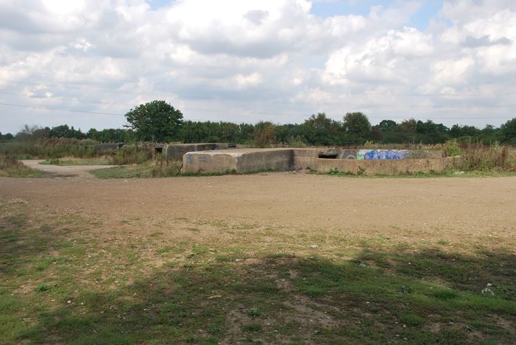
The monument includes the standing and buried remains of a Cold War Heavy
Anti-aircraft battery (gun emplacements, generator block, a connecting section
of the access road and a control room) located on the north eastern side of
the hamlet of Halls Green, to the north of the Epping Road (B181). It lies
within two separate areas of protection.
The battery, documented in War Office records as `LN (London North) 70 Tyler's
Cross', was constructed on a greenfield site and became operational in 1949-
50. It was listed as part of the London/South East section of the national
defence plan, known as `Igloo', in 1951, and appears to have been retained
until the national anti-aircraft battery system was stood down in 1955.
Although the site was not permanently equipped with weapons, the battery
maintained positions for four 3.7-inch guns, arranged at intervals of about
12m to form a shallow arc at the northern end of the complex. These
emplacements survive largely intact, each one surrounded by an octagonal
concrete wall and linked to an access road running along the southern side of
the array. Remains of wooden ammunition racking survive in some of the
internal recesses within the emplacement walls and spigot acceptance rings
remain visible in the floors of the emplacements indicating the presence of
the central holdfasts prepared for the guns.
The standby generator block is situated some 60m to the west of the eastern
gun emplacement. This reinforced concrete building measures approximately
7sq m and 3m high. It formerly contained the plant which provided electricity
to the guns and operational systems, making the site independent of the
national power supply. The single room, entered through a double door in the
southern elevation, was ventilated by a series of rectangular holes below the
ceiling and three larger vents in the eastern wall, all of which were probably
covered by metal cowls (now absent). Rows of metal hooks around the outer roof
line suggest that the building could be disguised with camouflage netting. The
intervening section of the access road, which connects the generator block
with the emplacements, has its original surface visible and contributes to
understanding the layout of the site; this is included in the scheduling.
The access road continues beyond the generator building, curving to the south
east and then extending some 260m southwards towards the entrance to the site
on Epping Road. The control room lies to the east of the access road some 130m
to the south of the generator block in a separate area of protection. This
building, a reinforced concrete structure measuring some 8m by 11m, is divided
into two rooms which housed the command post for the coordination of the guns.
There are two entrances, one for each room, and a single window which could
have been sealed with steel shutters.
All fences and fenceposts are excluded from the scheduling, although the
ground beneath them is included.
MAP EXTRACT
The site of the monument is shown on the attached map extract.
Legacy
The contents of this record have been generated from a legacy data system.
- Legacy System number:
- 29473
- Legacy System:
- RSM
Sources
Books and journals
Dobinson, C, 'Twentieth Century Fortifications in England' in The Cold War, , Vol. XI, (1998), 232
Other
List generated by EH Cold War Project, Cocroft, W, (2000)
NMR UID:1198555, Cocroft, W, Post-war Anti-Aircraft battery, Halls Green, (1998)
SMR No. 19151, Nash, F, Cold War HAA Gun Site, Halls Green, Roydon, (2000)
WO106/5912 (Copy, EH Cold War Project, War Office, Consolidated list of HAA Gun Positions for the full scale force, (1951)
Legal
This monument is scheduled under the Ancient Monuments and Archaeological Areas Act 1979 as amended as it appears to the Secretary of State to be of national importance. This entry is a copy, the original is held by the Department for Culture, Media and Sport.

Map
This map is for quick reference purposes only and may not be to scale. This copy shows the entry on 17-Jun-2025 at 08:57:44.
Download a full scale map (PDF)© Crown copyright [and database rights] 2025. OS AC0000815036. All rights reserved. Ordnance Survey Licence number 100024900.© British Crown and SeaZone Solutions Limited 2025. All rights reserved. Licence number 102006.006.
End of official list entry


