Pendennis peninsula fortifications
Listed on the National Heritage List for England. Search over 400,000 listed places
Overview
- Heritage Category:
- Scheduled Monument
- List Entry Number:
- 1012134
- Date first listed:
- 09-Oct-1981
Location
Location of this list entry and nearby places that are also listed. Use our map search to find more listed places.
Use of this mapping is subject to terms and conditions.
This map is for quick reference purposes only and may not be to scale.
What is the National Heritage List for England?

The National Heritage List for England is a unique register of our country's most significant historic buildings and sites. The places on the list are protected by law and most are not open to the public.
The list includes:
🏠 Buildings
🏰 Scheduled monuments
🌳 Parks and gardens
⚔️ Battlefields
⚓ Shipwrecks
Historic England Archive
Search over 1 million photographs and drawings from the 1850s to the present day using our images archive.
Find PhotosOfficial list entry
- Heritage Category:
- Scheduled Monument
- List Entry Number:
- 1012134
- Date first listed:
- 09-Oct-1981
- Date of most recent amendment:
- 26-Jan-1993
Location
The building or site itself may lie within the boundary of more than one authority.
- District:
- Cornwall (Unitary Authority)
- Parish:
- Falmouth
- National Park:
- N/A
- National Grid Reference:
- SW 81976 32244, SW 82079 32165, SW 82415 31877
Reasons for Designation
This is one of the finest examples of a post-medieval defensive promontory fort in the country. Pendennis was developed as a strategic naval base from its foundation in the 1540's, until it was demilitarised in the 1950's. The buildings of the Henrician and Elizabethan castle demonstrate developing gunnery methods, as do the batteries. The Civil War defences incorporating hornworks and a redoubt, are prominent and Pendennis had particular significance as a staunch Royalist stronghold, besieged in 1646, and as an important Royalist port throughout the Civil War. The 18th, 19th and 20th century works illustrate important changes in weaponry and defences and in barrack accommodation and domestic use of the grounds. Pendennis, a major naval base for over 400 years, demonstrates the development of coastal defence from Tudor to modern times and having been de-commissioned in the mid-twentieth century, has not suffered losses due to recent demolition or development.
Details
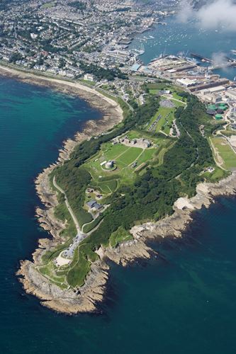
Pendennis peninsula projects south-eastwards into Falmouth Bay and, with St
Anthony's Head and St Mawes, guards the entrance to the Carrick Roads, a
large natural anchorage with a long and distinguished commercial and naval
history. The headland incorporates numerous important defensive structures
dating from the Prehistoric period to the 20th century, having been in
continuous military occupation from the 16th century onwards. Remains include
the probable site of an Iron Age cliff castle; an Early Tudor artillery fort
(SW82433178), with tower, chemise and Governor's lodging, and a blockhouse,
Little Dennis, at the waterline (SW82743154). The fort and blockhouse were
developed in the reign of Elizabeth I (SW82383187) and added to in the 17th,
18th and 19th centuries. They are both Listed Grade I. There is also a half
moon battery, built in the early 19th century and modified in the 20th
century, a system of Civil War defences in the form of hornworks and other
lines extending from the castle (SW82253206) and a forward defence at Upton's
Mount (SW82003228), as well as batteries at Crab Quay (SW82633170) and Little
Dennis. 19th century works include additions at Crab Quay battery and Middle
Point battery (SW82623181) and generator rooms and stores on the east side
(SW82563179), associated with the use of mines in the estuary. In the 20th
century a pre-First World War main barrack block, water tower (SW82083216)and
forward observation post (SW82083223) were built; batteries were upgraded and
zig-zag slit trenches (SW81943227) were dug during the two World Wars. The
extensive garrison garden on the south-western side of the headland was
developed into a pleasure garden complex in the 19th century (SW82243183)
Castle Drive, its associated carpark and visitor area, the road to the
fort from the north-west, an area of private housing and quay on the north-
east side of the headland (SW82503210), the above ground parts of the modern
electricity sub-station within the hornworks, and the coastguard station are
excluded from the scheduling as are the barracks and stores, however the
ground beneath all these modern standing buildings is included in the
scheduling. The 20th century forward observation post has now been demolished
and is not included in the scheduling.
MAP EXTRACT
The site of the monument is shown on the attached map extract.
Legacy
The contents of this record have been generated from a legacy data system.
- Legacy System number:
- 10552
- Legacy System:
- RSM
Sources
Books and journals
Morley, B, The Castles of Pendennis and St Mawes, (1988), 2-14
Other
Project proposals in file, Cornwall Archaeological Unit, Pendennis Project proposals,
Project proposals in file, Cornwall Archaeological Unit, The Pendennis Project,
SMR 18709.21 and .22,
SMR 18709.23,
SMR 18709.31,
SMR 18709.41,
SMR 18709.43,
SMR 18709.53,
SMR 18709.55,
SMR 18709.76, .73, .77, .86, .71,
SMR 18709.82,
SMR 18709.85,
Legal
This monument is scheduled under the Ancient Monuments and Archaeological Areas Act 1979 as amended as it appears to the Secretary of State to be of national importance. This entry is a copy, the original is held by the Department for Culture, Media and Sport.

Map
This map is for quick reference purposes only and may not be to scale. This copy shows the entry on 16-Apr-2025 at 12:39:59.
Download a full scale map (PDF)© Crown copyright [and database rights] 2025. OS AC0000815036. All rights reserved. Ordnance Survey Licence number 100024900.© British Crown and SeaZone Solutions Limited 2025. All rights reserved. Licence number 102006.006.
End of official list entry


