Bradenstoke Priory and fishponds and an associated motte and earthworks at Clack Mount.
Listed on the National Heritage List for England. Search over 400,000 listed places
Overview
- Heritage Category:
- Scheduled Monument
- List Entry Number:
- 1010807
- Date first listed:
- 10-Nov-1940
Location
Location of this list entry and nearby places that are also listed. Use our map search to find more listed places.
Use of this mapping is subject to terms and conditions.
This map is for quick reference purposes only and may not be to scale.
What is the National Heritage List for England?

The National Heritage List for England is a unique register of our country's most significant historic buildings and sites. The places on the list are protected by law and most are not open to the public.
The list includes:
🏠 Buildings
🏰 Scheduled monuments
🌳 Parks and gardens
⚔️ Battlefields
⚓ Shipwrecks
Historic England Archive
Search over 1 million photographs and drawings from the 1850s to the present day using our images archive.
Find PhotosOfficial list entry
- Heritage Category:
- Scheduled Monument
- List Entry Number:
- 1010807
- Date first listed:
- 10-Nov-1940
- Date of most recent amendment:
- 23-Oct-1992
Location
The building or site itself may lie within the boundary of more than one authority.
- District:
- Wiltshire (Unitary Authority)
- Parish:
- Lyneham and Bradenstoke
- National Grid Reference:
- ST 99661 79129
Reasons for Designation
From the time of St Augustine's mission to re-establish Christianity in AD 597
to the reign of Henry VIII, monasticism formed an important facet of both
religious and secular life in the British Isles. Settlements of religious
communities, including monasteries, were built to house communities of monks,
canons (priests), and sometimes lay-brothers, living a common life of
religious observance under some form of systematic discipline. It is estimated
from documentary evidence that over 700 monasteries were founded in England.
These ranged in size from major communities with several hundred members to
tiny establishments with a handful of brethren. They belonged to a wide
variety of different religious orders, each with its own philosophy. As a
result, they vary considerably in the detail of their appearance and layout,
although all possess the basic elements of church, domestic accommodation for
the community, and work buildings. Monasteries were inextricably woven into
the fabric of medieval society, acting not only as centres of worship,
learning, and charity, but also, because of the vast landholdings of some
orders, as centres of immense wealth and political influence. They were
established in all parts of England, some in towns and others in the remotest
of areas. Many monasteries acted as the foci of wide networks including parish
churches, almshouses, hospitals, farming estates and tenant villages. Some 225
of these religious houses belonged to the order of St Augustine. The
Augustinians were not monks in the strict sense, but rather communities of
canons - or priests - living under the rule of St Augustine. In England they
came to be known as `black canons' because of their dark coloured robes and to
distinguish them from the Cistercians who wore light clothing. From the 12th
century onwards, they undertook much valuable work in the parishes, running
almshouses, schools and hospitals as well as maintaining and preaching in
parish churches. It was from the churches that they derived much of their
revenue. The Augustinians made a major contribution to many facets of medieval
life and all of their monasteries which exhibit significant surviving
archaeological remains are worthy of protection.
Bradenstoke priory survives comparatively well in close proximity to the
additional earthwork complex associated with Clack Mount. Clack Mount is
believed to represent the site of a motte and bailey castle, a medieval
fortification introduced by the Normans and which usually comprised a mound of
earth or stone surmounted by a tower of stone or timber designed to command a
strategic position. An embanked enclosure or bailey containing subsidiary
buildings appears to have been linked to the motte. The close association
between the medieval priory earthworks and those of the motte clearly
demonstrate the complex relationship that existed between such elements of the
medieval landscape. As such they are particularly important in any study of
settlement, administration and ecclesiastical organisation during the medieval
period. Apart from buried archaeological material, survival of environmental
evidence, relating to the landscape in which the monument was constructed, is
possible from the various sealed old land surfaces and from the silts of the
fishponds.
Details
The monument comprises an extensive complex of medieval earthworks including
the remains of Bradenstoke Augustinian Priory, various earthworks including
fishponds, together with the remains of an associated motte and bailey castle
known as Clack Mount. Bradenstoke Priory, dedicated to St Mary and also known
as Bradenstoke Abbey and Clack, was founded as a house of Augustinian canons
in 1142 and remained in Augustinian hands until its dissolution in 1539. The
remains of the priory, comprising a substantial part of the 14th century hall
and undercroft of the guest house or Kings Lodgings, formerly the west range
of the priory, were subsequently used as a farmhouse. Nearby was a tithe barn
of 15th century date and a holy well. Investigation of the priory site in the
1920s resulted in the recovery of the plan of the monastic buildings and the
12th century church lying south of the cloisters. Finds from the site have
included numerous medieval burials, some with stone coffins and several tiled
pavements.
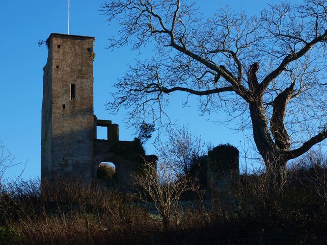
Much of the fabric of the surviving monastic buildings was removed in 1929
by the then owner Randolph Hearst; he had most of the surviving west range and
the tithe barn demolished, removing the fabric for re-use at St Donat's in
Glamorgan and his estate in America. Today the surviving buildings are limited
to the undercroft of the guest hall with a 14th century garderobe tower at its
north-west corner; both are in a ruinous condition. The site of the holy well
is today the position of a natural spring with no trace of any masonry.
To the north-east of the priory, linking it to the site of Clack Mount,
are a series of linear earthworks and fishponds. These include two fishponds,
both orientated north-west to south-east, the most southerly having dimensions
of 70m by 20m and that to the north-east 50m by 20m. A system of ditches and
banks links these fishponds to the ditch of the enclosure surrounding Clack
Mount, forming an extensive water management system. Between the two fishponds
are a series of linear ditches 7m wide and 0.9m deep; these form a roughly
square enclosure with sides of 70m. A low mound 7m in diameter and 0.4m high
is situated in the south-west corner of this enclosure. A low bank 6m wide and
0.3m high can be traced from the south-east corner of Clack Mount enclosure
running south-east for 70m before turning south-west for 140m and then turning
north-west, it appears to pre-date the present field boundary and could
represent an outer bailey associated with the motte and bailey of Clack Mount.
Clack Mount motte and bailey lies immediately to the north of the ponds on
a prominence with commanding views to the north and west. The mound itself is
steep sided and circular in shape with a diameter of 20m; it stands to a
height of 1.8m. It has been identified as Scufa's barrow, an Anglo Saxon
boundary mark mentioned in AD 850. As such it would predate the other
earthworks, but this association remains unproven. Evidence of collapsed
masonry, incorporated into the fabric of the mound, suggests that it may have
supported a stone tower. Enclosing the area of the motte is a trapezoidal
enclosure with sides averaging 70m long defined by a ditch 10m wide and 1.5m
deep with an outer bank 8m wide and 0.6m high. A second bank and ditch lay
outside and parallel to the north-east side of this enclosure. This has been
largely levelled by old plough erosion, though the bank remains recognisable.
The trapezoidal enclosure is linked to and clearly contemporary with, the
previously mentioned earthworks to the south-west.
All modern buildings and structures, including the concrete tank at
ST99777935, all boundary features, metalled surfaces and roads are excluded
from the scheduling, although the ground beneath these features is included.
MAP EXTRACT
The site of the monument is shown on the attached map extract.
Legacy
The contents of this record have been generated from a legacy data system.
- Legacy System number:
- 19041
- Legacy System:
- RSM
Sources
Books and journals
E P N S, , Place names Wilts, (1939), 271
Knowles, D , Medieval Religious Houses: England and Wales, (1971), 129
Styles, D, The Victoria History of the County of Wiltshire , (1956), 275
Walters, R C S, Holy Wells of Gloucs, (1928), 160-1
Grundy, G B, 'The Archaeological Journal' in The Archaeological Journal, , Vol. 76, (1919), 166-7
Other
Brakspear, H, WAM (43), (1925)
Brakspear, H, WAM (45), (1930)
Brakspear, H, WAM (47), (1935)
Conversation, Gomme, Mr ,
WAM (19), (1880)
Legal
This monument is scheduled under the Ancient Monuments and Archaeological Areas Act 1979 as amended as it appears to the Secretary of State to be of national importance. This entry is a copy, the original is held by the Department for Culture, Media and Sport.

Map
This map is for quick reference purposes only and may not be to scale. This copy shows the entry on 16-Apr-2025 at 16:30:32.
Download a full scale map (PDF)© Crown copyright [and database rights] 2025. OS AC0000815036. All rights reserved. Ordnance Survey Licence number 100024900.© British Crown and SeaZone Solutions Limited 2025. All rights reserved. Licence number 102006.006.
End of official list entry


