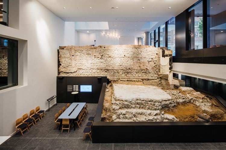
London Wall: remains of Roman wall and bastion (4a) at Crutched Friars
Listed on the National Heritage List for England. Search over 400,000 listed places
Overview
- Heritage Category:
- Scheduled Monument
- List Entry Number:
- 1002069
- Date first listed:
- 29-May-1952
Location
Location of this list entry and nearby places that are also listed. Use our map search to find more listed places.
Use of this mapping is subject to terms and conditions.
This map is for quick reference purposes only and may not be to scale.
What is the National Heritage List for England?

The National Heritage List for England is a unique register of our country's most significant historic buildings and sites. The places on the list are protected by law and most are not open to the public.
The list includes:
🏠 Buildings
🏰 Scheduled monuments
🌳 Parks and gardens
⚔️ Battlefields
⚓ Shipwrecks
Historic England Archive
Search over 1 million photographs and drawings from the 1850s to the present day using our images archive.
Find PhotosOfficial list entry
- Heritage Category:
- Scheduled Monument
- List Entry Number:
- 1002069
- Date first listed:
- 29-May-1952
- Date of most recent amendment:
- 07-Mar-2016
- Location Description:
- Basement of Roman Wall House, 1-2 Crutched Friars and Emperor House, 35-36 Vine Street, London EC3, centred on NGR TQ33580 81011.
Location
The building or site itself may lie within the boundary of more than one authority.
- County:
- Greater London Authority
- District:
- City and County of the City of London (London Borough)
- Parish:
- Non Civil Parish
- National Grid Reference:
- TQ3358081010
Summary
Part of the Roman wall known as London Wall including bastion number 4a.
Reasons for Designation
The part of London Wall at Crutched Friars, including remains of the Roman wall and bastion number 4a, is scheduled for the following principal reasons: * Archaeological and historic importance: London Wall was pivotal to the protection of London from the Roman period until far into the Middle Ages and was a key factor in determining the shape and development of the city; * Survival: this part of London Wall incorporates standing remains (within basements) that are up to 3m high above the level of the plinth, as well as the remains of bastion number 4a; * Documentation (archaeological): this part of the Wall has been recorded through several excavations, providing important information regarding Roman and medieval civil engineering and construction techniques; * Potential: the Wall retains potential for further investigation into its history and construction; * Group value: this part of the Wall holds group value with the other surviving scheduled sections of London Wall and more widely with the scheduled Roman amphitheatre and public bath houses.
History
London Wall was constructed as part of an extensive programme of Roman public works between approximately AD 190 and AD 225. The Wall was about 3km long and enclosed an area of nearly 330 acres. It served to form the basis of the protection of the town far into the medieval period, and was also a key factor in determining the shape and development of both Roman and medieval London. The uniformity of design and construction of the C2 wall suggests that it was planned and built as a single project. It enclosed the whole of the landward side of the town from Tower Hill to Blackfriars, incorporating an existing military fort at Cripplegate. It was laid out in straight sections, linking the major routeways into London, and gateways were constructed at the points of entry at Aldgate, Bishopsgate, Newgate and Ludgate. Excavation has indicated that during the later Roman period a riverside wall was constructed parallel to the north bank of the Thames to complete the defensive circuit of London. The defensive nature of much of the Wall's circuit was strengthened by an external ditch, with the exception of those areas where the marshland around the Walbrook acted as a natural defensive feature. Internally, it was strengthened by a bank of earth.
The Roman Wall was built on a trench foundation of puddled clay, and included a rubble core interspersed with bonding tile courses. It is known to have stood to a height of approximately 4.4m above a sandstone plinth, and is considered to have been surmounted by a parapet walkway. Excavation has indicated that defensive bastions were added to the Wall in the C4, and a number were also added during the medieval period when the Wall was repaired and refortified. By the mid C16, however, with the continued expansion of London, its function as a town boundary and defence had ceased. London Wall survives in various states of preservation. Some parts of the Wall, especially along the eastern section, still stand to almost full height and the bastions are also clearly visible. Other parts are no longer visible above the present ground surface, but in these areas sections of the Wall survive as buried features, and sufficient evidence exists for their positions to be accurately identified for much of its length.
The eastern section of the Wall is recorded in various documentary sources. An account by John Stow (c1525-1605) records that the external ditch was re-cut in 1213 and the Wall was repaired in 1215, 1282, 1328 and 1477. The Wall is shown on the 1561 Agas map, Faithorne and Newcourt’s map of 1658, Hollar’s ‘Exact’ Survey of the City of London 1667 and on Ogilby and Morgan’s map of 1677. By the time of Rocque’s map of 1746 this section of the Wall had been built over.
INVESTIGATION HISTORY
The section of the Wall at Crutched Friars was first excavated in 1905 during the construction of Roman Wall House when a 12.2m stretch of the western face of the Wall was revealed, 2.1m thick, 2.4 - 2.7m high and with a base c2.6m below ground level. It was reported in the Daily Graphic of 9 May 1905 and a 6.5m long section was preserved in the lower ground floor of the new building with a basement constructed beneath. Additional supporting brick piers were added beneath the Wall, probably necessitated by vibration from bombing during the Second World War. The eastern face of this section of the Wall was not exposed until the redevelopment of 8-10 Crosswall and 6 Vine Street to create Emperor House in 1979-80. A total length of c22.5m was recorded with a 10m stretch surviving 3m in height. Excavations also revealed the remains of a previously unknown bastion (Number 4a) at the northern end of the stretch of Wall. Opening up work in December 2014 and January 2015 revealed that a thin section of the rubble core of the Wall extends approximately 5m to the south of the exposed section of Wall within modern party walls.
Details
The monument includes a section of the Roman wall at Crutched Friars which forms part of the property boundary of Emperor House to the east and Roman Wall House to the west and is visible within their basements. It represents part of the eastern side of the London Wall circuit and includes a fragment of walling, 11m in length, with an additional section of its core to the south (located behind C20 party walling) and the remains of a bastion extending from the eastern face of the Wall. The Wall stands on a foundation trench of puddled clay and flint with a capping of ragstone which forms a raft supporting the main body of the Wall. The Wall itself rises from a sandstone plinth and has a rubble and mortar core faced with Kentish ragstone banded at intervals by tile courses. The section of Wall at Crutched Friars stands almost to its third tile course, approximately 3m above the level of the plinth. The base of the plinth is at c11.4m OD. The Wall is supported and topped by a C20 concrete and brick superstructure. The western face is protected by a glass screen in a former nightclub. The section of the core of the wall at the southern end of the site runs for 5m and is 0.31m wide
The remains of the C4 bastion are located on the eastern face of the Wall, towards the northern end of the site. Rectangular in plan, the foundations project 5.4m from the face of the Wall. The excavation showed that the foundations of the bastion have been stepped into the backfill of the C2 ‘V’-shaped ditch which is considered to be contemporary with the original construction of the Wall. The stepping of the foundations helped prevent subsidence. The solid ‘D’-shaped superstructure of the bastion comprises similar material to the Wall itself and included reused monumental masonry with fragments of an inscribed Roman tombstone, probably early C3 in date. Although a number of bastions on London Wall are known to have been reused during the medieval period the excavation of bastion number 4a recovered evidence that it had fallen out of use by the C13 and been lowered to the present height. The remains of the bastion are protected by a C20 brick retaining wall.
The scheduled area includes a 2m buffer around the wall and its bastion for the support and protection of the monument.
EXCLUSIONS
A number of features are excluded from the scheduling: these include the modern brick and concrete which now supports the eastern external face of the Wall, the brickwork which supports the Wall on the western face and the glass display chamber, the modern brickwork surmounting the wall on the eastern face, the walling which surrounds the bastion, the modern party walling enclosing the section of core at the south end of the site and all restaurant furniture, light fittings and display boards. The ground beneath all these features is, however, included.
Legacy
The contents of this record have been generated from a legacy data system.
- Legacy System number:
- LO 26 F
- Legacy System:
- RSM - OCN
Sources
Books and journals
Merrifield, R, The Roman City of London, (1965)
Milne, G, Roman London, (1995)
Maloney, John , 'Recent work on London's Defences' in Maloney, John, Hubley, Brian, Roman Urban Defences in the West, (1983), 96-117
Maloney, J, 'The Discovery of Bastion 4A in the City of London and its implications' in Transactions of the London and Middlesex Archaeological Society, , Vol. 31, (1980), 68-76
Other
MOLA - Roman Wall House (35-36 Vine Street and 1-2 Crutched Friars) London EC3 - Historic Environment Assessment (January 2013)
MOLA - Roman Wall House (35-36 Vine Street and 1-2 Crutched Friars), London EC3 - Interim Report (June 2015)
Legal
This monument is scheduled under the Ancient Monuments and Archaeological Areas Act 1979 as amended as it appears to the Secretary of State to be of national importance. This entry is a copy, the original is held by the Department for Culture, Media and Sport.

Map
This map is for quick reference purposes only and may not be to scale. This copy shows the entry on 16-Apr-2025 at 17:03:38.
Download a full scale map (PDF)© Crown copyright [and database rights] 2025. OS AC0000815036. All rights reserved. Ordnance Survey Licence number 100024900.© British Crown and SeaZone Solutions Limited 2025. All rights reserved. Licence number 102006.006.
End of official list entry


