CHAPELFIELD GARDENS
Listed on the National Heritage List for England. Search over 400,000 listed places
Overview
- Heritage Category:
- Park and Garden
- Grade:
- II
- List Entry Number:
- 1001645
- Date first listed:
- 26-Sep-2002
Location
Location of this list entry and nearby places that are also listed. Use our map search to find more listed places.
Use of this mapping is subject to terms and conditions.
This map is for quick reference purposes only and may not be to scale.
What is the National Heritage List for England?

The National Heritage List for England is a unique register of our country's most significant historic buildings and sites. The places on the list are protected by law and most are not open to the public.
The list includes:
🏠 Buildings
🏰 Scheduled monuments
🌳 Parks and gardens
⚔️ Battlefields
⚓ Shipwrecks
Historic England Archive
Search over 1 million photographs and drawings from the 1850s to the present day using our images archive.
Find PhotosAlso of interest

Official list entry
- Heritage Category:
- Park and Garden
- Grade:
- II
- List Entry Number:
- 1001645
- Date first listed:
- 26-Sep-2002
The scope of legal protection for listed buildings
This list entry identifies a Park and/or Garden which is registered because of its special historic interest.
The scope of legal protection for listed buildings
This list entry identifies a Park and/or Garden which is registered because of its special historic interest.
Location
The building or site itself may lie within the boundary of more than one authority.
- County:
- Norfolk
- District:
- Norwich (District Authority)
- Parish:
- Non Civil Parish
- National Grid Reference:
- TG 22583 08375
Details
A Victorian public park, designed by George Alden Stevens, on ground used for public benefit since at least 1655 and on which walks had been laid out in 1746. The gardens are the earliest surviving ornamental public open space in Norwich.
HISTORIC DEVELOPMENT
Chapel Fields takes its name from the college of St Mary-in-the-Fields with which the land was associated until the Dissolution in 1545. Initially this open space was granted to a private citizen but it was sold to the city in 1569, to be held in trust, and to begin with it was leased for use as archery butts and grazing land. By 1655 however the city leases included the 'rights of citizens of ingress and egress ... to walk for their recreation at all times' and in 1707 the grounds were railed in. During the middle of the C18 the lease was held by Sir Thomas Churchman who planted three main walks with avenues of elm around the perimeter of the site which became 'a place of much promenade particularly on Sunday afternoons' (Taigel 1995). Towards the end of the C18 however the city corporation leased the central area to the Waterworks Company who constructed a reservoir and water tower which greatly detracted from the attraction of the surrounding walks. By the 1840s the site had become 'the resort of loose and idle boys and being occupied partly by washerwomen seems to be in great measure deserted by respectable citizens' (contemporary accounts, quoted in Taigel 1995). In 1852 the Waterworks Company agreed to give up their lease if the city corporation laid out the land as a public garden. An elaborate plan prepared by the company was subsequently simplified and in 1866 the Prince and Princess of Wales planted a Wellingtonia to mark the agreement of the council to lay out the gardens. In 1867 an iron palisade was erected to enclose the site, a Drill Hall was erected, replacement planting in the elm avenues took place, and several dignitaries planted specimen trees. In 1880 a pagoda designed by Barnard, Bishop and Barnard was erected (later known as the pavilion; now the site of the present refreshment building). By 1899 a bandstand and children's play area had also been added. During the early part of the C20 the elaborate serpentine walks were somewhat simplified and the pagoda/pavilion was restored, before finally being demolished in 1949. In 1963 when the city inner ring road was constructed the Drill Hall was demolished and the corner of the gardens where Chapel Field Road meets Chapel Field North was lost. The site remains (2002) a public garden in the ownership of the city council.
DESCRIPTION
LOCATION, AREA, BOUNDARIES, LANDFORM, SETTING
Chapelfield Gardens lies on the south-west edge of the old city of Norwich, close to what is now the city centre. The c 2.4ha triangular site occupies level ground, with artificial banking along the north-west boundary, and is enclosed by roads on all sides: Chapel Field North to the north-east, Chapel Field East to the south-east, and Chapel Field Road to the south-west, along which ruins of the old city wall survive. Since 1886 the boundaries of the garden have changed, with the removal of the grounds on the outside of the old city wall to the west, and the loss of the north-west corner through the construction of the inner ring road.
ENTRANCES AND APPROACHES
The gardens have several pedestrian entrances: one at each of the three corners of the site and another in the centre of the Chapel Field Road boundary, via a subway under the busy inner ring road. Although the subway dates from the 1960s, this entrance is close to an earlier western entrance, marked where the path leads into the gardens by two mature London plane trees. The entrance at the southern tip is as shown on the 1886 OS map, while the gates to the north-east, north, and north-west are all new, the north-west corner dating from the completion of the inner ring road and Grapes Hill roundabout.
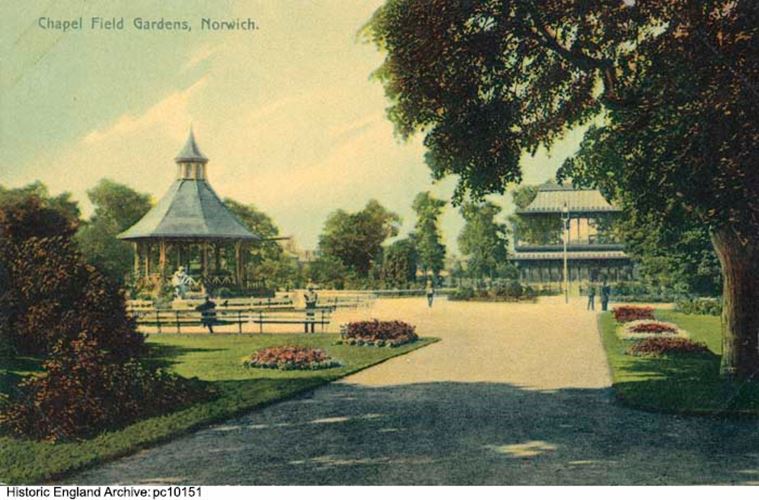
PRINCIPAL BUILDING
There are three buildings on the garden site. The timber bandstand with plain and fish-scale tile roof, located c 70m from the north-east corner entrance, is set on a circular area of tarmac and was erected in this position in c 1899. On the edge of the tarmacked area, c 30m to the north-west of the bandstand, is a brick and tile refreshment shelter, built on broadly the same position and footprint as the pagoda which was erected when the gardens opened. In the north-west corner of the gardens is a refreshment pavilion, of black weatherboarding under a cedar shingle roof, which was erected at the beginning of the C20. It now (2002) houses a restaurant.
GARDENS AND PLEASURE GROUNDS
Chapelfield Gardens is broadly triangular in shape. The entrances into the gardens are connected to each other by straight tree-lined walks around the perimeter of the site. These walks were originally planted with elms by Sir Thomas Churchman in 1746, to be used as public promenades. They appear to have been continuously retained as avenues since that time, although the current avenues contain a variety of species and ages, mostly of late C19 and C20 origin, and the north and west avenues were truncated when the Drill Hall was demolished to make way for the Grapes Hill roundabout in the 1960s. The east avenue is the most regular, being all lime, mostly c 100 years old. The western avenue is primarily lime, of mixed ages, with elm, cherry, and plane. Along Chapel Field North the walk is again lined predominantly with lime but here there are also planes and oaks.
From the perimeter walks tarmac paths lead into the gardens and take serpentine routes to the circle enclosing the bandstand and refreshment shelter. The path layout which survives today (2002) is a simplified and altered version of that which is shown on the OS map of 1886, of which only the broad outline can be determined. Between the paths, areas of grass are interspersed with beds of mixed shrub planting, added during the C20, and on the south side of the restaurant is a children's play area.
REFERENCES
A Taigel, Norfolk Town Gardens Survey, (report for Norfolk Gardens Trust 1995)
N Pevsner and B Wilson, The Buildings of England: Norfolk 1, Norwich and the North-east (1998), p 318
Maps
1:500 map of Norwich city, 1880 (Norfolk Local Studies Library)
OS 25" to 1 mile: 1st edition published 1883
2nd edition published 1905
3rd edition published 1914
1937 edition
Archival items
Norfolk Gardens Trust, unpublished notes on the history of Chapelfield Gardens (c 2000) [copy on EH file]
Description written: July 2002
Register Inspector: EMP
Edited: November 2002
Legacy
The contents of this record have been generated from a legacy data system.
- Legacy System number:
- 5162
- Legacy System:
- Parks and Gardens
Legal
This garden or other land is registered under the Historic Buildings and Ancient Monuments Act 1953 within the Register of Historic Parks and Gardens by Historic England for its special historic interest.

Map
This map is for quick reference purposes only and may not be to scale. This copy shows the entry on 14-May-2025 at 17:10:20.
Download a full scale map (PDF)© Crown copyright [and database rights] 2025. OS AC0000815036. All rights reserved. Ordnance Survey Licence number 100024900.© British Crown and SeaZone Solutions Limited 2025. All rights reserved. Licence number 102006.006.
End of official list entry


