CLACTON SEAFRONT GARDENS
Listed on the National Heritage List for England. Search over 400,000 listed places
Overview
- Heritage Category:
- Park and Garden
- Grade:
- II
- List Entry Number:
- 1001626
- Date first listed:
- 28-Jun-2002
Location
Location of this list entry and nearby places that are also listed. Use our map search to find more listed places.
Use of this mapping is subject to terms and conditions.
This map is for quick reference purposes only and may not be to scale.
What is the National Heritage List for England?

The National Heritage List for England is a unique register of our country's most significant historic buildings and sites. The places on the list are protected by law and most are not open to the public.
The list includes:
🏠 Buildings
🏰 Scheduled monuments
🌳 Parks and gardens
⚔️ Battlefields
⚓ Shipwrecks
Historic England Archive
Search over 1 million photographs and drawings from the 1850s to the present day using our images archive.
Find PhotosAlso of interest

Official list entry
- Heritage Category:
- Park and Garden
- Grade:
- II
- List Entry Number:
- 1001626
- Date first listed:
- 28-Jun-2002
The scope of legal protection for listed buildings
This list entry identifies a Park and/or Garden which is registered because of its special historic interest.
The scope of legal protection for listed buildings
This list entry identifies a Park and/or Garden which is registered because of its special historic interest.
Location
The building or site itself may lie within the boundary of more than one authority.
- County:
- Essex
- District:
- Tendring (District Authority)
- Parish:
- Non Civil Parish
- National Grid Reference:
- TM 17502 14435
Details
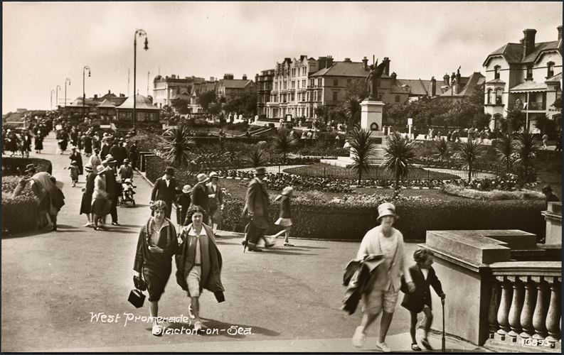
Seafront gardens laid out to a design by the County Surveyor, Daniel Bowe, in 1921.
HISTORIC DEVELOPMENT
The original settlement of Great Clacton began to develop as a seaside resort in the mid C19, at which time it became known as Clacton-on-Sea. In 1864, a railway engineer called Peter Schuyler Bruff acquired the land at Clacton Beach and began to plan a new resort. In 1871 he produced a master plan which incorporated pleasure grounds, clifftop gardens on either side of a new pier, and a mixed development of villas, lodgings, and hotels. This plan marks the site where the seafront gardens were to be created as 'pleasure grounds'. By 1899 the land on the east side of Pier Gap had been turned into public gardens, complete with a bandstand, while the land to the west remained as lawns with the area closest to Pier Gap planted with formal displays of bedding. In 1921, the Urban District Council decided to spend 'considerable sums in laying out gardens, providing shelters etc' (J Instit Municipal & County Engineers 1933) and four formal gardens, known as the Marine Gardens, were laid out to designs by the County Surveyor, Daniel J Bowe. In 1924 the formal bedding displays closest to Pier Gap were redesigned to include a war memorial designed by Charles Hartwell. As soon as they were opened to the public the gardens became extremely popular and have retained their style and popularity ever since. In the late 1990s the gardens were restored and updated. The site remains (2002) in local authority ownership.
DESCRIPTION
LOCATION, AREA, BOUNDARIES, LANDFORM, SETTING
The Seafront Gardens at Clacton are located in the centre of the resort, on the south-west side of the Pier, with fine views out to sea. The long, thin, c 0.5ha level site is bounded to the north-west by Marine Parade West, to the north-east by Pier Gap (a short drive linking Marine Parade to the Pier), and to the south-east by a narrow band of cliffs leading down to Kings Parade, a pedestrian promenade running along the beach. At the south-west end of the gardens, the land between Kings Parade and Marine Parade West is laid to grass banks, partially planted in a naturalistic fashion.
ENTRANCES AND APPROACHES
There are pedestrian access points to each of the five garden areas from both Marine Parade West and the seaward boundary. In addition, the garden areas are divided from each other by pedestrian links between Marine Parade West and Kings Parade, and there are entrances from each of these links.
GARDENS
The Seafront, or Marine Gardens are divided into five separate compartments, running north-east to south-west from Pier Gap. The first compartment contains the War Memorial Garden which was used as an area for formal bedding schemes until 1924 when the First World War Memorial was erected to designs by Charles Hartwell, and gardens were laid out around it. They are enclosed by a clipped Euonymus hedge and mature hollys on the town side and are laid to grass. A pattern of beds for annual bedding survives little altered since 1924, as do the structural cordylines planted here. The war memorial is reached by a path from the seaward boundary and is surrounded by a path set with seating. A path linking Marine Parade West to the sea forms the division between the Memorial Garden and the next compartment, the Rose Garden.
The sunken Rose Garden is enclosed by low stone walls and a line of mature pines along the town boundary. Steps lead down from entrances on each of the four boundaries to a crazy-paving path which runs between areas of lawn cut with beds filled with roses. Retaining walls on the town and seaward sides form the edge to mixed borders and a late C20 pergola creates the central feature of this garden. The Rose Garden, created in 1921, has always contained roses but none of the original planting survives apart from the boundary pines. The recent restoration has recreated a rose garden but with a wider diversity of species than the original design intended.
The steps in the south-west end of the Rose Garden lead up to a further link between Marine Parade West and the sea, on which stands a 1921 circular pavilion divided into four sections containing seats. The recently restored shelter is white rendered and has Doric columns and latticework windows (currently, 2002, boarded up) under a green tile roof. On the south-west side of the pavilion lies the sunken flower garden, now (2002) called the 1920s Sunken Garden. As with the Rose Garden, low stone walls enclose the area which is reached via sets of steps in each of its boundary walls, with mixed borders planted along the retaining walls. Crazy-paving paths lead through lawns cut with beds filled with annual bedding in which survive original 1921 cordyline plantings, to a central 1990s sundial. The layout of this area remains the same as it was when the Sunken Garden was created in 1921 although its original bedding and clipped greens have been replaced in the late 1990s by planting in the style of a 1920s private garden.
Leaving the 1920s Sunken Garden on the south-west boundary, steps lead up to another link between town and sea on which stands a square seating pavilion of the same detail and date as the circular pavilion. Beyond this lies the fourth garden area, which has been laid out as a Mediterranean Garden as part of the late 1990s restoration. Mediterranean plants are placed in drifts through gravel paths, within which some mature shrub planting, most notably macrocarpas, together with mature ilex on the town side, has been retained. In 1921 this compartment was laid out as a level garden with a central walk running between grass verges backed by mixed borders.
Leaving the Mediterranean Garden on the south-west boundary, the exit leads to the final pavilion, set on another link between town and sea. This 1921 seating shelter is circular, like that between the Rose Garden and the Sunken Garden, with similar details apart from the columns which here are brick. On the south-west side of the shelter lies the final garden compartment, known now (2002) as the Sensory Garden. The boundary with the town retains several mature ilex and pines, while a central crazy-paving path runs between grass verges flanked by mixed borders containing several original 1921 macrocarpas. In 1921 this level garden had straight grass verges which were altered as part of the late 1990s restoration, at which time the new planting was given a sensory theme.
Beyond the Sensory Garden, outside the area here registered, the planting becomes more informal with mixed shrubs planted on banks between Marine Parade West and the cliffs to the sea.
REFERENCES
J Instit Municipal & County Engineers (1933) [paper by A Aiston entitled 'Notes on Clacton-on-Sea']
K Walker, The History of Clacton (1966) [copy at Essex Local Studies Library]
Clacton Seafront and Marine Gardens, (The Landscape Partnership c 1990s) [copy on EH file]
Maps
P Bruff, Outline of Intended New Watering Place called Clacton-on-Sea, 1871 (reproduced in J Instit Municipal & County Engineers 1933)
OS 6" to 1 mile: 1925 edition
1939 edition
OS 25" to 1 mile: 1st edition published 1874
2nd edition published 1897
1923 edition
1939 edition
Description written: February 2002
Register Inspector: EMP
Edited: November 2002
This List entry has been amended to add sources for War Memorials Online and the War Memorials Register. These sources were not used in the compilation of this List entry but are added here as a guide for further reading, 11 July 2017.
Legacy
The contents of this record have been generated from a legacy data system.
- Legacy System number:
- 5124
- Legacy System:
- Parks and Gardens
Sources
Websites
War Memorials Online, accessed 11 July 2017 from https://www.warmemorialsonline.org.uk/memorial/204494
War Memorials Online, accessed 11 July 2017 from https://www.warmemorialsonline.org.uk/memorial/101405
War Memorials Register, accessed 11 July 2017 from http://www.iwm.org.uk/memorials/item/memorial/22698
War Memorials Register, accessed 11 July 2017 from http://www.iwm.org.uk/memorials/item/memorial/22697
Legal
This garden or other land is registered under the Historic Buildings and Ancient Monuments Act 1953 within the Register of Historic Parks and Gardens by Historic England for its special historic interest.

Map
This map is for quick reference purposes only and may not be to scale. This copy shows the entry on 14-May-2025 at 17:27:00.
Download a full scale map (PDF)© Crown copyright [and database rights] 2025. OS AC0000815036. All rights reserved. Ordnance Survey Licence number 100024900.© British Crown and SeaZone Solutions Limited 2025. All rights reserved. Licence number 102006.006.
End of official list entry


