FISHBOURNE ROMAN PALACE
Listed on the National Heritage List for England. Search over 400,000 listed places
Overview
- Heritage Category:
- Park and Garden
- Grade:
- II*
- List Entry Number:
- 1001211
- Date first listed:
- 01-Jun-1984
Location
Location of this list entry and nearby places that are also listed. Use our map search to find more listed places.
Use of this mapping is subject to terms and conditions.
This map is for quick reference purposes only and may not be to scale.
What is the National Heritage List for England?

The National Heritage List for England is a unique register of our country's most significant historic buildings and sites. The places on the list are protected by law and most are not open to the public.
The list includes:
🏠 Buildings
🏰 Scheduled monuments
🌳 Parks and gardens
⚔️ Battlefields
⚓ Shipwrecks
Historic England Archive
Search over 1 million photographs and drawings from the 1850s to the present day using our images archive.
Find PhotosOfficial list entry
- Heritage Category:
- Park and Garden
- Grade:
- II*
- List Entry Number:
- 1001211
- Date first listed:
- 01-Jun-1984
The scope of legal protection for listed buildings
This list entry identifies a Park and/or Garden which is registered because of its special historic interest.
The scope of legal protection for listed buildings
This list entry identifies a Park and/or Garden which is registered because of its special historic interest.
Location
The building or site itself may lie within the boundary of more than one authority.
- County:
- West Sussex
- District:
- Chichester (District Authority)
- Parish:
- Fishbourne
- National Grid Reference:
- SU 83961 04767
Details
A C1 AD formal Roman courtyard garden, enclosed within the partly excavated wings of a Roman palace and reconstructed according to field evidence revealed through excavation and planted in accordance with known contemporary planting styles.
HISTORIC DEVELOPMENT
The site at Fishbourne was first occupied by the Romans as a military base in the early stages of the invasion of Britain, from AD 43(75. Its abandonment for military purposes was quickly followed by two stages of building for residential use, the second of these occurring between AD 65 and 75 until, in AD 75, the site was cleared and levelled for the construction of the present palace, possibly for the British client king Togidubnus. From AD 100 to 200 it underwent considerable change and development until in the 280s it was destroyed by fire. Subsequent stone robbing, weathering, worm and agricultural activity reduced the contours to an even slope. Although the sporadic discovery of Roman artefacts was recorded from 1805, proper investigation of the site and the identification of a major, late C1 building only took place following the cutting of a trench for a water-main in 1960. A series of major excavations, which brought to light the history and the scale and structure of the Palace, its gardens and surroundings, took place between 1961 and 1968. The Sussex Archaeological Society acquired much of the site and established the present museum which opened to the public in 1968. This remains (1997) in their ownership while the rest of the (unexcavated) site is in multiple public and private ownership.
DESCRIPTION
LOCATION, AREA, BOUNDARIES, LANDFORM, SETTING
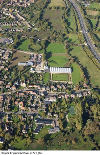
Fishbourne Roman Palace lies c 1km to the west of Chichester, on both sides of the A259 east to west Chichester to Havant road. The c 0.75ha registered site comprises that area of the scheduled ancient monument which is occupied by the Palace and its enclosed courtyard garden and lies on level ground. It is bounded to the east by a tree-lined stream and to the north by post and wire fencing. Beyond the boundaries are narrow strips of marginal grassland with, on their north side, the main east to west coastline railway and on their east side, the embankment of the Chichester by-pass. To the west, the site abuts the museum's car and coach park and the housing of Fishbourne while to the south, beyond the housing which covers the southern, unexcavated areas of the registered site is a landscape of flat pasture land around the northern end of the east arm of Chichester harbour.
ENTRANCES AND APPROACHES
The site is approached on the west side from Salthill Road and Roman Way, a surfaced drive running due east from the end of Roman Way into the car and coach park, in the south-east corner of which is the entrance to the museum building and the excavated areas of the Palace. During its occupied lifetime, the Palace was approached from due east, its large entrance hall linked to a road running to Chichester.
PRINCIPAL BUILDING
The palace building covers an area of c 2.3ha which extends north from, and includes, the main A259 road. Constructed from AD 75, on an artificially created, two-level platform, it consisted of four large wings fronted by a colonnaded verandah and ranged around a central open space, the west wing being built some 1.5m above the level of the remaining wings. The north and east wings each contain a small, enclosed, private courtyard garden. The villa's main entrance was in the centre of the east wing, opposite an audience chamber in the west wing. The footings of the north wing, which have been completely exposed and display many mosaic-floored rooms, are housed in a glazed timber building which forms part of the present museum complex. The northern parts of the east and west wings lie beneath open grassed areas while their southern parts and the whole of the south wing, which field evidence shows to have also had a verandah along its south-facing side, lie entirely beneath adjacent housing and the A259. The Palace was built on a site occupied from AD 43 to 75 first by timber-built military granaries and then by further timber structures for residential use. These were replaced by a finely finished stone building erected between AD 65 and 75 but never completed, which lay to the south of the A259.
GARDENS AND PLEASURE GROUNDS
The formal garden, of which the northern half has been reconstructed on the evidence of excavated bedding trenches, lies within the 75m by 100m rectangle formed by the north wing, the northern halves of the east and west wings, and the rear boundary fences of the properties on the A259. The southern half of the rectangle lies beneath these properties. The rectangle is bisected by a 12m wide, axial pathway, the northern 6m width of which has been relaid, which linked the western audience chamber with the entrance hall. The central, open area of the rectangle is laid to lawn (there is no field evidence of planting) with subsidiary paths running around the perimeter. Excavation indicated that all the paths were defined by narrow bedding trenches dug into the clay and filled with marled loam. These are now (since 1968) planted with two closely spaced lines of c 0.6m high, clipped box, those along the north side of the axial path comprising a broad band of regularly spaced, alternating semicircular and square recesses and those defining the north and west paths forming a narrower band with a smaller scale pattern of recesses. At the east end of the axial path, a small length of its full 12m width, with a matching band of box hedging, has been recreated.
The eastern perimeter path is planted along its east side with three closely spaced lines of box hedging with, on their east side against the line of the eastern colonnade, a 1.2m wide border of roses. Field evidence, including evidence of postholes, indicated a different type of planting here, possibly one needing structural support. On its west side, the path is lined with a border of acanthus and, 6.1m further west along the edge of the lawn, a row of regularly spaced, espaliered fruit trees has been replanted from field evidence of postholes and bedding pits. On the west side of the lawn is a specimen cypress tree, planted on the site of the only bedding pit discovered on the lawn. No direct evidence survives to indicate the species of plants originally used in the garden, those in the re-created garden having been chosen from those shown in contemporary wall paintings and in written records.
At the eastern end of the axial path, just to the east of its junction with the eastern perimeter path, a concrete pool marks the site of a marble-lined basin which stood within the entrance hall of the Palace. There is also field evidence, in the form of extensive ceramic water mains running along the outer edges of the paths, for the likely presence of fountains and basins, these possibly sited in the hedge recesses. To the south of the pool and extending south to the boundary with the A259 is a demonstration garden, laid out in 1995 with a triclinium (an outdoor eating area), a kitchen garden of ten beds containing plants grown and used in the Roman period, a small orchard and a garden museum.
On the south side of the south wing, outside the registered area but within that of the scheduled ancient monument, trial excavations on private land indicate that its colonnade opened onto an artificial terrace which extended some 90m southwards and terminated at a quay wall and the sea. The terrace, which would have formed the private garden attached to the south residential wing, seems to have been laid out as a natural garden with a large pond and an artificial water supply. Evidence in the form of short lengths of bedding trenches and isolated pits suggests an informal layout of trees and shrubs. To the north-west of the Palace and also outside the registered area, in the angle between the north and the west wings, the thickness of the black soil and the presence of occupational rubbish shown in excavation suggests that this was the site of the kitchen garden.
REFERENCES
I Nairn and N Pevsner, The Buildings of England: Sussex (1965), p 224
B Cunliffe, A Roman Palace and its Garden (1971)
Fishbourne Roman Palace, guidebook, (Fishbourne 1994)
C Taylor, The Archaeology of Gardens (1983), pp 30-1
C Riley, Roman Plants Guide (1997)
Description written: November 1997
Amended: January 2000
Register Inspector: VCH
Edited: June 2000
Legacy
The contents of this record have been generated from a legacy data system.
- Legacy System number:
- 2217
- Legacy System:
- Parks and Gardens
Legal
This garden or other land is registered under the Historic Buildings and Ancient Monuments Act 1953 within the Register of Historic Parks and Gardens by Historic England for its special historic interest.

Map
This map is for quick reference purposes only and may not be to scale. This copy shows the entry on 16-Apr-2025 at 16:59:48.
Download a full scale map (PDF)© Crown copyright [and database rights] 2025. OS AC0000815036. All rights reserved. Ordnance Survey Licence number 100024900.© British Crown and SeaZone Solutions Limited 2025. All rights reserved. Licence number 102006.006.
End of official list entry


