Overview
- Heritage Category:
- Maritime Wreck
- List Entry Number:
- 1000084
- Date first listed:
- 23-May-2006
Location
Location of this list entry and nearby places that are also listed. Use our map search to find more listed places.
Use of this mapping is subject to terms and conditions.
This map is for quick reference purposes only and may not be to scale.
What is the National Heritage List for England?

The National Heritage List for England is a unique register of our country's most significant historic buildings and sites. The places on the list are protected by law and most are not open to the public.
The list includes:
🏠 Buildings
🏰 Scheduled monuments
🌳 Parks and gardens
⚔️ Battlefields
⚓ Shipwrecks
Historic England Archive
Search over 1 million photographs and drawings from the 1850s to the present day using our images archive.
Find PhotosOfficial list entry
- Heritage Category:
- Maritime Wreck
- List Entry Number:
- 1000084
- Date first listed:
- 23-May-2006
- Location Description:
- Off Norman's Bay, East Sussex
The scope of legal protection for listed buildings
This list entry identifies a protected site which is understood to be the site of a vessel lying wrecked on or in the seabed. It's protected because of the historical, archaeological or artistic importance of the vessel, or of objects contained or formerly contained in it which may be lying on the seabed in or near the wreck.
Location
The building or site itself may lie within the boundary of more than one authority.
- Latitude:
- 50.80294500
- Longitude:
- 0.41063300
- National Grid Reference:
- TQ6996003146
Summary
Possible remains of wreck of English or Dutch warship of the seventeenth- to eighteenth-centuries which stranded in Norman's Bay, East Sussex. It is thought possibly to be either the remains of the Third Rate Resolution, lost in the Great Storm of 1703, or of any one of a number of Dutch vessels lost during the Battle of Beachy Head, 1690; an alternative candidate is an unidentified vessel lost in the same area in 1667.
History
The initial interpretation of the site is that it may be the wreck of the Resolution, a 70-gun Third Rate that sank during the Great Storm of 1703. However, limited documentary research indicates that there are at least three other recorded losses within the Bay that might relate to the remains seen. Therefore, on the basis of the current limited level of investigation, all that may be said with certainty is that the archaeological remains are consistent with that of a large warship of the period 1600 to 1800.
Details
Designation History:
Designation Order: No 1392, 2006
Made: 23rd May 2006
Laid before Parliament: 24th May 2006
Coming into force: 14th June 2006
Protected area: 100 metres within 50 48.1767 N 000 24.6380 E
No part of the restricted area lies above the high-water mark of ordinary spring tides.
Documentary History:
The size and the number of guns found on site are indicators of the vessels' possible identity as the Resolution or one of the Dutch vessels lost in the Battle of Beachy Head.
The strongest candidates for the Dutch warships lost in 1690 are the Vriesland and the Wapen Van Utrecht. Additionally the Maagd Van Enkhuizen, the Elswout, the Tholen and two unnamed warships are further candidates from this battle.
In 1985, the Nautical Museums Trust heard of salvors looking for the wreck of the Resolution. The Ministry of Defence was approached with a view to acquiring the wreck to prevent its destruction and the Warship Resolution Trust was set up, to which the wreck was given.
Archaeological History:
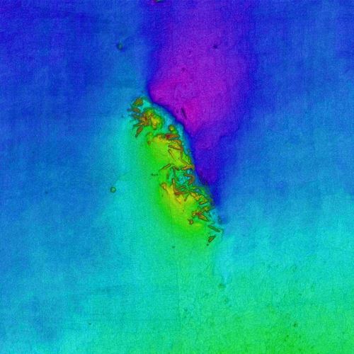
In 2005, local divers discovered the site, comprising at least 45 iron guns, other artefacts and a timber hull structure, while attempting to free a lobster pot. The seabed within the area searched appears to be largely flat with a compressed clay/aggregate mixture overlain by silt and fine, loose, sand, which seemed to be highly mobile. The wreck mound, largely composed of ballast stones and iron guns, is surrounded by a slight scour trench. The mound is not continuous but is highest at the northern end of the site, approximately 1.5 metres high, although individual guns may project another 0.5 metre higher than this. (4) The discovery was reported to staff at the Shipwreck and Coastal Heritage Centre, Hastings.
In addition, a copper cauldron, a brick, a wrought iron bolt and concretion and a cast iron shot recovered by divers some years ago and believed to be from the Norman's Bay site was anonymously handed in.
Fieldwork in 2007 assessed the suitability of timbers for dendrochronological sampling, with 11 timbers selected for analysis from the hull structure, since these appeared to still be in situ. Here, ten large samples of exposed sections of framing timbers were taken from the eastern side of the wreck mound for analysis. Interpretation has confirmed that the timber is consistent with tree-ring sequences from Germany and the Low Countries, indicating the vessel's likely origin.
While the Resolution certainly foundered in Pevensey Bay and archival research has identified a probable area for the position of loss fairly close to the wreck site as investigated, all that can currently be said with certainty is that the archaeological remains are consistent with a large warship of the period 1600 to 1800.
Legacy
The contents of this record have been generated from a legacy data system.
- Legacy System number:
- 1441075
- Legacy System:
- AMIE - Wrecks
Sources
Other
Norman's Bay Wreck: Designated Site Assessment: Archaeological Report, November 2006
Norman's Bay Wreck: Designated Site Assessment: Archaeological Report, Wessex Archaeology, November 2007, Ref: 53111.03zz
Wessex Archaeology, April 2006, Norman's Bay Wreck, East Sussex: Undesignated Site Assessment,
Legal
This site is designated under the Protection of Wrecks Act 1973 as it is or may prove to be the site of a vessel lying wrecked on or in the sea bed and, on account of the historical, archaeological or artistic importance of the vessel, or of any objects contained or formerly contained in it which may be lying on the sea bed in or near the wreck, it ought to be protected from unauthorised interference. Protected wreck sites are designated by Statutory Instrument. The following information has been extracted from the relevant Statutory Instrument.
Statutory Instrument
Information provided under the Statutory Instrument heading below forms part of the official record of a protected wreck site. Information provided under other headings does not form part of the official record of the designation. It has been compiled by Historic England to aid understanding of the protected wreck site.
Statutory Instruments: 2006/1392

Chart
This map is for quick reference purposes only and may not be to scale. This copy shows the entry on 21-Apr-2025 at 17:31:27.
Download a full scale chart (PDF)© Crown copyright [and database rights] 2025. OS AC0000815036. All rights reserved. Ordnance Survey Licence number 100024900.© British Crown and SeaZone Solutions Limited 2025. All rights reserved. Licence number 102006.006.
End of official list entry


