Overview
- Heritage Category:
- Maritime Wreck
- List Entry Number:
- 1000075
- Date first listed:
- 12-Jan-1974
Location
Location of this list entry and nearby places that are also listed. Use our map search to find more listed places.
Use of this mapping is subject to terms and conditions.
This map is for quick reference purposes only and may not be to scale.
What is the National Heritage List for England?

The National Heritage List for England is a unique register of our country's most significant historic buildings and sites. The places on the list are protected by law and most are not open to the public.
The list includes:
🏠 Buildings
🏰 Scheduled monuments
🌳 Parks and gardens
⚔️ Battlefields
⚓ Shipwrecks
Historic England Archive
Search over 1 million photographs and drawings from the 1850s to the present day using our images archive.
Find PhotosOfficial list entry
- Heritage Category:
- Maritime Wreck
- List Entry Number:
- 1000075
- Date first listed:
- 12-Jan-1974
- Location Description:
- Spithead, off Portsmouth
The scope of legal protection for listed buildings
This list entry identifies a protected site which is understood to be the site of a vessel lying wrecked on or in the seabed. It's protected because of the historical, archaeological or artistic importance of the vessel, or of objects contained or formerly contained in it which may be lying on the seabed in or near the wreck.
Location
The building or site itself may lie within the boundary of more than one authority.
- Latitude:
- 50.76391460
- Longitude:
- -1.10424481
- National Grid Reference:
- SZ 63271 96418
Summary
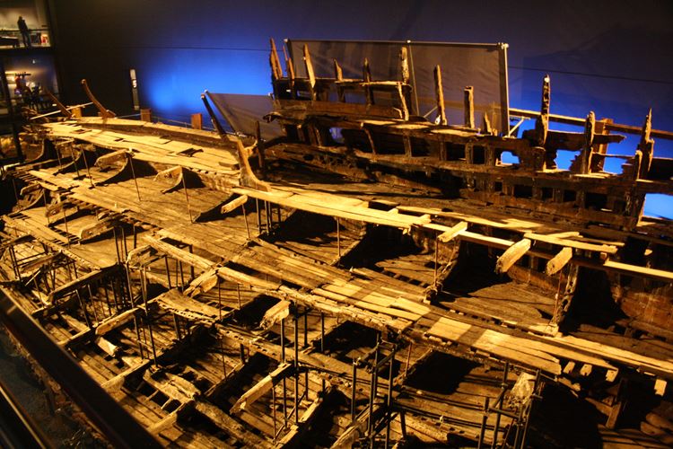
The remains of the Mary Rose, Henry VIII's flagship built in 1509, which sank off Southsea Castle on July 19, 1545 with enormous loss of life as the King watched his warships engage the French fleet. A large section of the remains were raised in 1982 and are displayed by the Mary Rose Trust, whilst part of the stem post and anchor were recovered in 2005. The remainder of the wreck, still on the seabed, is designated as a protected wreck site.
History
Built in 1509, the Mary Rose served 29 years as a warship before being rebuilt in 1536, increasing her capacity to 700 tons. The ship, acknowledged as the pride of King Henry VIII, capsized and sank in 1545 whilst engaging a French invasion fleet.
In 1965 the diving research group 'Project Solent Ships' initiated the search for the Mary Rose. After several exploratory dives, sonar investigations in 1967 indicated a large buried anomaly, resulting in the formation of the 'Mary Rose 1967 Committee' which was superseded by the Mary Rose Trust in 1979. Diver reconnaissance continued until 1971 when timbers, exposed by severe gales, were observed. The site was designated in 1974.
Excavations from 1979-82 recovered over 22,000 artefacts, and culminated in the raising of a large section of the hull. In subsequent years the Mary Rose Trust has carried out monitoring, survey and small scale excavation of the site, as significant sections of the hull and artefact assemblage remain on the seabed.
Details
Designation History:
Designation Order: (No 1), No 55, 1974
Made: 12th January 1974
Laid before Parliament: 18th January 1974
Coming into force: 5th February 1974
Protected area: 300 metres within 50 45 48 N 001 06 10 W
No part of the restricted area lies above the high-water mark of ordinary spring tides.
Documentary History:
Built in 1509 and re-built 1539, the Mary Rose went into battle against the French off Spithead in July 1545 but as she turned towards them she capsized and took down her captain, Sir George Carew, and almost all of her crew. The popular accepted explanation for this is that her gunports were left open, but other contemporary sources point to insubordination. Long and costly efforts were made to raise her to no avail.
Venetian salvage contractors Petre de Andreas and Symone de Maryne worked into August trying to raise the wreck, which was keeled on her port side with the masts and yards well out of the water. By August 5th her sails and sail yards had been removed and brought ashore, but the angle of the keel meant the salvage attempt failed. Additional guns were salvaged from her by an Italian diver called Peter Paul.
In 1836 John Deane was asked by five Gosport fishermen, John Henry Richard, William Burnett, Jas Richard, Job Redman and William Burnett Jr to clear an obstruction on the bottom and as a result a number of cannon were recovered, the first on the 16th June, including a 68pdr cannon royal, 9pdr culverin bastard and a 32 pdr demi-cannon and a large wrought iron gun and part of a smaller similar gun.
A crater caused by exploding six 13-inch shells allowed timber to be removed and sold at auction; it was in excellent condition and the souvenirs made from it are still well preserved.
In the 1840s divers from the Royal Engineers were to salvage material from the ROYAL GEORGE but misread the position. As a consequence, five brass cannon were raised bearing the date 1535, along with twenty iron guns.
On the 5th September 1840 a brass culverin 17pdr calibre along with four 32pdrs constructed of wrought iron bars and hoops and several smaller guns were recovered. Two archers bows made of yew and a Cologne-ware jug were also recovered. On the 30th October two more large iron guns were recovered before operations ceased.
Archaeological History:
In the winter of 1964-65, 'Project Solent Ships' came into being with fellow members of Southsea Sub Aqua Club. Among the vessels targeted were the Royal George (1782), Boyne (1795) and the Mary Rose (1545). The Mary Rose was discovered in 1967.
In 1969 a trial trench was begun which was carried on in 1970 using water jets in an area where sub-bottom sonar showed an anomaly. Several pieces of oak, a plank, a staghorn and a large cleat were recovered as well as the barrel of an iron gun made from a single plate of wrought iron with an iron ball in the breech. The plans for 1971 were changed when it was discovered that seabed scour had uncovered part of the frames of the hull which were protruding 3-4 inches. Work continued to determine how much of the vessel remained. It was estimated that 30ft of hull remained and that some internal timbers had collapsed but were in good condition. A second iron gun was recovered with a stone cannon ball. Oak and elm timbers recovered were in good condition and the planking tight with preserved treenails; it was therefore thought possible to raise the vessel.
Distinct mounds covered the southern, northern and eastern side of the vessel thought to be the bow, stern and port side. The frames along the western side of the ship were surveyed and a shallow excavation undertaken at the southern end. This revealed a continuation of frames and vertical planking across the transom of the ship which seems to lie on a northerly heading. (9) Oak and elm timbers recovered were in good condition and the planking tight with preserved treenails; it was therefore thought possible to raise the vessel.
Excavation of the site was embarked upon culminating in 1982 when the hull remains were raised and put on display in Portsmouth Dockyard, along with many of the finds from the site. Fragments of the wreck remain on the seabed and the site is monitored by the Mary Rose Trust. Some 800 timbers were removed from the wreck before she was raised. The rigging elements recovered from the Mary Rose are the earliest known and are a variety of single and double blocks.
Report produced April 2006. In 2002 the Ministry of Defence (MoD) proposed a deep-water channel to accommodate two new aircraft carriers, whose preferred route cut into the eastern section of the designated circle. A Project Design was drafted and an excavation licence granted, funded by the MoD, and work continued into the 2004 season. The MoD subsequently proposed two new routes for the channel which do not impact on the designated circle. The MoD continued to fund the 2005 season which included the raising of an anchor and the stem post by the Mary Rose Trust with subsequent backfilling on the site
Fragments of the wreck remain on the seabed along with the spoil heaps and a large indentation left when the hull was raised.
Legacy
The contents of this record have been generated from a legacy data system.
- Legacy System number:
- 1121974
- Legacy System:
- AMIE - Wrecks
Sources
Legal
This site is designated under the Protection of Wrecks Act 1973 as it is or may prove to be the site of a vessel lying wrecked on or in the sea bed and, on account of the historical, archaeological or artistic importance of the vessel, or of any objects contained or formerly contained in it which may be lying on the sea bed in or near the wreck, it ought to be protected from unauthorised interference. Protected wreck sites are designated by Statutory Instrument. The following information has been extracted from the relevant Statutory Instrument.
Statutory Instrument
Information provided under the Statutory Instrument heading below forms part of the official record of a protected wreck site. Information provided under other headings does not form part of the official record of the designation. It has been compiled by Historic England to aid understanding of the protected wreck site.
Statutory Instruments: 1974/55

Chart
This map is for quick reference purposes only and may not be to scale. This copy shows the entry on 21-Apr-2025 at 11:25:35.
Download a full scale chart (PDF)© Crown copyright [and database rights] 2025. OS AC0000815036. All rights reserved. Ordnance Survey Licence number 100024900.© British Crown and SeaZone Solutions Limited 2025. All rights reserved. Licence number 102006.006.
End of official list entry


