CORONATION OFFSHORE
Listed on the National Heritage List for England. Search over 400,000 listed places
Overview
- Heritage Category:
- Maritime Wreck
- List Entry Number:
- 1000069
- Date first listed:
- 03-Mar-1978
Location
Location of this list entry and nearby places that are also listed. Use our map search to find more listed places.
Use of this mapping is subject to terms and conditions.
This map is for quick reference purposes only and may not be to scale.
What is the National Heritage List for England?

The National Heritage List for England is a unique register of our country's most significant historic buildings and sites. The places on the list are protected by law and most are not open to the public.
The list includes:
🏠 Buildings
🏰 Scheduled monuments
🌳 Parks and gardens
⚔️ Battlefields
⚓ Shipwrecks
Historic England Archive
Search over 1 million photographs and drawings from the 1850s to the present day using our images archive.
Find PhotosOfficial list entry
- Heritage Category:
- Maritime Wreck
- List Entry Number:
- 1000069
- Date first listed:
- 03-Mar-1978
- Location Description:
- Off Rame Head / Penlee Point, Cornwall
The scope of legal protection for listed buildings
This list entry identifies a protected site which is understood to be the site of a vessel lying wrecked on or in the seabed. It's protected because of the historical, archaeological or artistic importance of the vessel, or of objects contained or formerly contained in it which may be lying on the seabed in or near the wreck.
Location
The building or site itself may lie within the boundary of more than one authority.
- Latitude:
- 50.31009246
- Longitude:
- -4.20076981
- National Grid Reference:
- SX 43393 47889
Summary
Remains of the offshore section of an English Second Rate warship which sprang a leak and capsized on returning to Plymouth from a Channel patrol in 1691. The wreck lies in two parts and at the time there were conflicting accounts as to what had happened, some eyewitnesses stating that she had capsized and foundered, others that she had stranded. It is possible that she parted as she went down, or, alternatively, that she struck the land and broke up.
History
The Coronation, a 90 gun second rate was built in 1685 by Isaac Betts at Portsmouth dockyard as one of the 1677 thirty-ships programme. She measured 161ft by 45ft, weighed approximately 1,427 tons and had a crew of 660 men during wartime. The Coronation took part in the British defeat at the Battle of Beachy Head on June 30th 1690, where she carried the Flag of Vice-Admiral Sir Ralph Delaval, commander of the Blue Squadron. On the 3rd September 1691 after patrolling for the French fleet, the English Fleet under Russell made for Plymouth. The Coronation foundered in a strong gale from the South East whilst trying to round Penlee Point with a loss of all but 13 of her crew including the Captain, Charles Skelton.
Details
Designation History:
Designation Order: (No 2), No 321, 1978
Made: 3rd March 1978
Laid before Parliament: 10 March 1978
Coming into force: 31st March 1978
Protected area: 150 metres within 50 18.57 N 004 11.98 W
No part of the restricted area lies above the high-water mark of ordinary spring tides.
Documentary History:
The Coronation had been on patrol with the Channel Fleet, when the weather had turned bad and she had run for Plymouth Sound, hoping to gain shelter from the oncoming SSE gales. The actual details of her loss are unclear. The Admiralty Report stated that '...ye Coronation, which was oversett off ye Ramhead, on ye Coast of Cornwall. Resolved, that the opinion of the Court is, that by a Butt-head starting, or some Planke giving way Shee sprung a Leake, and thereby was lost.' It seems Skelton knew of this leak and had ordered the masts cut, but it had been to no avail and she had capsized. However, when she sank she was not carrying her full complement. Around 600 men including the Captain drowned, and only 22 men got ashore alive.
It is unclear how the wreckage became spread between the offshore and the inshore sites. It is possible that the Coronation, after capsizing, broke up, leaving wreckage at the offshore site, before drifting in and smashing up the main part of the ship on Penlee Point. Or if not this, then the reverse - she broke up on Penlee Point and part of the wreckage was washed out to sea and sank at the offshore site. The origin of the wreckage on this site is not in dispute - the pewter plate with Captain Skelton's personal crest on it is a clear indication of the wreck's identity as the Coronation.
Archaeological History:
In 1977 having searched the area with a proton magnetometer, the Coronation Archaeology Group (CAG), received a strong reading over this site, and subsequent dives discovered at least 17 iron cannon and a large pewter plate with the personal crest of Captain Skelton.
Between 1981 and 1984 an extended survey of the offshore and inshore sites identified a total of 83 cannons covering an area stretching for approximately 1000 metres off Penlee Point. In 1996, further magnetometer survey of both of the Coronation sites was undertaken, and in 1999 an acoustic positioning 3D survey of the offshore site was compiled. The sites are now in an on-going state of survey with the aim of producing a detailed plan illustrating both sites, and the undefined debris trail in-between.
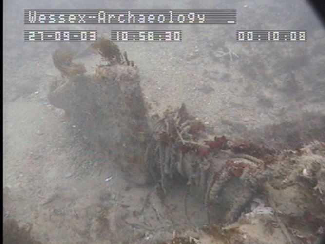
The offshore section of the Coronation lies in a general depth of 13 metres, in a rocky area with infilling sand. Only small pieces of wreckage remain.
Legacy
The contents of this record have been generated from a legacy data system.
- Legacy System number:
- 1082129
- Legacy System:
- AMIE - Wrecks
Sources
Books and journals
The Victoria History of the County of Hampshire: Volume V, (1912)
Colledge, J J, Ships of the Royal Navy: Volume 1, (1989)
Duffy, M, The New Maritime History of Devon, Volume 1: From Early Times to the Late Eighteenth Century, (1992)
Farr, G, Wreck and Rescue on the Devon Coast, (1968)
Hepper, D J, British Warship Losses in the Age of Sail, 1650-1859, (1994)
Lyon, D, The Sailing Navy List: All the Ships of the Royal Navy Built, Purchased and Captured 1688-1860, (1993)
Anderson, R C, 'The Society for Nautical Research occasional publications' in Lists Of Men-Of-War 1650-1700, Part 1 : English Ships 1649-1702, , Vol. 5, (1966)
Other
Maritime and Coastguard Agency: Receiver of Wreck Amnesty (23-Jan to 24-Apr-2001),
Legal
This site is designated under the Protection of Wrecks Act 1973 as it is or may prove to be the site of a vessel lying wrecked on or in the sea bed and, on account of the historical, archaeological or artistic importance of the vessel, or of any objects contained or formerly contained in it which may be lying on the sea bed in or near the wreck, it ought to be protected from unauthorised interference. Protected wreck sites are designated by Statutory Instrument. The following information has been extracted from the relevant Statutory Instrument.
Statutory Instrument
Information provided under the Statutory Instrument heading below forms part of the official record of a protected wreck site. Information provided under other headings does not form part of the official record of the designation. It has been compiled by Historic England to aid understanding of the protected wreck site.
Statutory Instruments: 1978/321

Chart
This map is for quick reference purposes only and may not be to scale. This copy shows the entry on 21-Apr-2025 at 17:31:26.
Download a full scale chart (PDF)© Crown copyright [and database rights] 2025. OS AC0000815036. All rights reserved. Ordnance Survey Licence number 100024900.© British Crown and SeaZone Solutions Limited 2025. All rights reserved. Licence number 102006.006.
End of official list entry


